Filter: County of Portage
Filter: Subject of transportation
Filter: County of Portage
Filter: Subject of transportation
| Date: | 1905 |
|---|---|
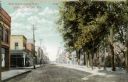
| Description: | View of Main Street, looking eastward. A drugstore and the Stevens Point Journal offices are on the right. Caption reads: "Main Street, looking East, Steve... |
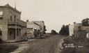
| Date: | 1910 |
|---|---|
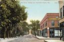
| Description: | View of a Main Street. A drugstore can be seen prominently on the left. Trees line the sidewalk on the right. Caption reads: "Main Street, looking West, St... |

| Date: | 1891 |
|---|---|
| Description: | Bird's-eye map of Stevens Point, looking east, with an inset of the Water Works. Wisconsin River in foreground with fifty-three business locations identifi... |
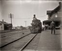
| Date: | |
|---|---|
| Description: | View down platform towards locomotive and train at the railroad station. There are people standing on the platform near the depot building. |

| Date: | |
|---|---|
| Description: | Colorized view depicting the Wisconsin Central Railroad bridge at Stevens Point, with several men standing on top of the bridge painting the structure. Cap... |
| Date: | |
|---|---|
| Description: | View across unpaved road towards the Opera House, with a man high up on a telephone pole in front of the building. Snow is on the ground. Caption reads: "O... |
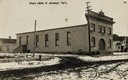
| Date: | 1905 |
|---|---|
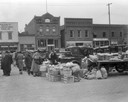
| Description: | View down unpaved street with commercial buildings. Caption reads: "St. Scene, Bancroft, Wis." |

| Date: | 1965 |
|---|---|
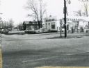
| Description: | Aerial view of town and Highway 66. |
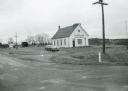
| Date: | 1971 |
|---|---|
| Description: | Spiritland Cafe, a restaurant located in a former church, with the cemetery in the background. The restaurant was located on CTH D in Portage County. |
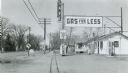
| Date: | 1958 |
|---|---|
| Description: | A gasoline station along US Highway 51 in Whiting, Portage County, attracted passing motorists with an attention-getting "gas for less" sign. |
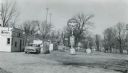
| Date: | 1958 |
|---|---|
| Description: | Flying A service station located on US Highway 51 in Whiting, Portage County. |
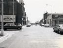
| Date: | 07 28 1970 |
|---|---|
| Description: | Traffic on Stevens Point's Second Street. |
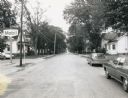
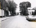
| Date: | 07 28 1971 |
|---|---|
| Description: | Older residences along Second Street in Stevens Point. |
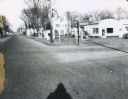
| Date: | 07 28 1971 |
|---|---|
| Description: | The Fourth Street intersection in Stevens Point. |
| Date: | 12 12 1966 |
|---|---|
| Description: | Texaco Oil service station, apparently built from a war surplus quonset hut-style building. |

| Date: | 11 29 1989 |
|---|---|
| Description: | Old bridge over Mill Creek on Highway G in Portage County. |

| Date: | 05 21 1968 |
|---|---|
| Description: | Rural tavern and gasoline station on STH 54. |
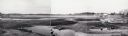
| Date: | 1958 |
|---|---|
| Description: | Plover River Pond; the dam was out and the pond is dry, permitting an unusual view of the immediate area. Highway 51 and a bridge can be seen in the distan... |
If you didn't find the material you searched for, our Library Reference Staff can help.
Call our reference desk at 608-264-6535 or email us at: