 Filter: FORMAT_DIMENSIONS of 44 x 52 cm.

| Date: | 1851 |
|---|---|
| Description: | A survey map of Wisconsin and eastern Minnesota, with the township surveys for portions of the Saint Croix region in progress. The maps also show the Meno... |
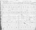
| Date: | 1900 |
|---|---|
| Description: | This photocopied map shows lot numbers, dimensions, and street names. The map is dated "June 4th, A.D. 1849" and includes certifications by Nathan Almstead... |

| Date: | 1719 |
|---|---|
| Description: | This extremely detailed and ornate map shows the cities, Native American land, mountains, lakes, rivers, and European claims of North America. An inset map... |
If you didn't find the material you searched for, our Library Reference Staff can help.
Call our reference desk at 608-264-6535 or email us at: