 Filter: Year of 1700-1799
Filter: Year of 1750-1759
Filter: Year of 1700-1799
Filter: Year of 1750-1759

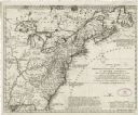
| Date: | 1755 |
|---|---|
| Description: | From "A map of the British and French dominions in North American with the roads, distances, limits, and extent of the settlements". |

| Date: | 1755 |
|---|---|
| Description: | Color map of North American territories owned by the English and by the French. Scale: about 115 milles d'Angleterre to 1 inch. French title is "Carte des ... |

| Date: | 1755 |
|---|---|
| Description: | Hand-colored. Paris: 1755. Scale [ca. 1:3,000,000]. |

| Date: | 1757 |
|---|---|
| Description: | The Canadian Lakes. Scale [ca. 1:6,500,000]. Paris: 1757. |

| Date: | 1750 |
|---|---|
| Description: | Map of the northeast corner of America and Canada with hand-colored boundaries. The map shows colonies, Native American nations, fishing areas, and detaile... |

| Date: | 1758 |
|---|---|
| Description: | This map of the north-west hemisphere shows the cities, lakes, rivers, mountains, and political borders. In the upper left corner sits a decorative cartouc... |

| Date: | 1755 |
|---|---|
| Description: | This map shows forts, missions, villages and cities, rivers and portages, and boundaries of the Spanish, English, and French territories, marking the large... |

| Date: | 1757 |
|---|---|
| Description: | This map shows the cities, plantations, lakes, rivers, mountains, Native American territories and colonial borders of the Eastern half of North America, pl... |

| Date: | 1755 |
|---|---|
| Description: | This map shows the eastern half of North America during the French and Indian war, including cities, borders, Native American Land, forts, and detailed geo... |

| Date: | 1758 |
|---|---|
| Description: | This detailed map of north eastern America shows the boundaries, cities, mountains, rivers, lakes, Native American land and towns, and roads from east of t... |

| Date: | 1759 |
|---|---|
| Description: | Map of North and South America showing regions, colonies, cities and settlements, rivers, lakes, and Native American land. Near the bottom left an inset ma... |

| Date: | 1755 |
|---|---|
| Description: | Large format map of America and Canada east of the Mississippi River. D'Anville marks the locations of rivers, lakes, settlements, cities, Native American ... |
| Date: | 1755 |
|---|---|
| Description: | Dutch map of America and parts of Canada east of the Mississippi based largely on the famous John Mitchell map. It shows rivers, lakes, mountains, settlem... |

| Date: | 1758 |
|---|---|
| Description: | Map showing lakes, rivers, cities, Native American land, and the boundaries of French and English claims in America and Canada north of New York. A title c... |

| Date: | 1755 |
|---|---|
| Description: | Map of North America east of the Mississippi River showing cities, settlements, Native American land, mountains, lakes, rivers, and the boundaries between ... |

| Date: | 1755 |
|---|---|
| Description: | Map of the northeastern portion of America and Canada, east of the Hudson River and south from Labrador. It names regions, colonies, cities, numerous forts... |

| Date: | 1759 |
|---|---|
| Description: | Map of north eastern Canada and parts of New England, showing settlements, cities, portages, Native American land, mountains, lakes, and rivers. The unusua... |
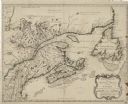
| Date: | 1755 |
|---|---|
| Description: | Bellin's landmark map of eastern Canada and part of northeast America extending from Newfoundland to the borders of Lake Ontario and south to Cape Cod. The... |

| Date: | 1752 |
|---|---|
| Description: | Map of the the coast line of Louisiana, focusing on the Mississippi, the Arkansas, the Red, the Osage, and the Missouri River. An inset map along the righ... |
If you didn't find the material you searched for, our Library Reference Staff can help.
Call our reference desk at 608-264-6535 or email us at:
