 Search: apostle
Search: islands
Search: apostle
Search: islands

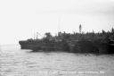
| Date: | 1963 |
|---|---|
| Description: | Gaylord Nelson, John F. Kennedy, and John Reynolds on the 1963 tour of the Apostle Islands. There is a U.S. Army helicopter in the background. |

| Date: | 1888 |
|---|---|
| Description: | This map shows counties, lakes, railroads, and rivers. Lake Michigan, Lake Superior, and the Apostle Islands are labeled. A table of railroad lines with mi... |
| Date: | 1920 |
|---|---|
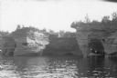
| Description: | View across water towards three men and a woman posing while standing in a wooden boat in a sea cave in the Apostle Islands. Rock formations and other sea ... |
| Date: | |
|---|---|
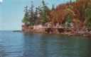
| Description: | Color postcard of a rocky shoreline on Devil's Island, part of the Apostle Islands of Lake Superior. |

| Date: | |
|---|---|
| Description: | Colorized postcard of a port hole through the north cape or point of Presque Isle or Stockton Island, part of the Apostle Islands. A person in a boat is ou... |

| Date: | 1907 |
|---|---|
| Description: | A map of the eastern portion of the Apostle Islands group, and a detailed map of Gull Island showing the relief on the island, are included here, along wit... |

| Date: | 1900 |
|---|---|
| Description: | This chart of the northern Apostle Islands and Lake Superior shoreline shows relief by contours and spot heights and depths by contours, gradient tints and... |

| Date: | 1914 |
|---|---|
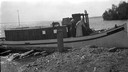
| Description: | Hull family boarding the "Lizzie W." from one of the Apostle Islands. |
| Date: | 1915 |
|---|---|
| Description: | Two women aboard the Hull family boat, the "Lizzie W.," while it is tied to shore at one of the Apostle Islands. |
| Date: | 1885 |
|---|---|
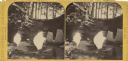
| Description: | Stereograph of a sailboat in Excursion Cave, on Hemlock Island of the Apostle Islands. A man can be seen sitting in the boat. |
| Date: | 1915 |
|---|---|
| Description: | Picnic on beach of one of the Apostle Islands, Lake Superior. Image includes Mrs. Chute, Mrs. Webb., Mrs. Hull, H.W. Rogers and Mr. Chute. |
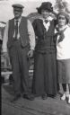
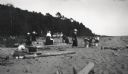
| Date: | 1913 |
|---|---|
| Description: | Captain Dan Angus stands next to Elsie Tough, and adolescent Anne Ashley, on a dock on one of the Apostle Islands. |
| Date: | 1912 |
|---|---|
| Description: | Picnic party on the rocks along the shore, among the Apostle Islands in Lake Superior. |
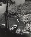
| Date: | 1956 |
|---|---|
| Description: | Elevated view of a rowboat moored in a small cove on Madeline Island in the Apostle Islands. |
| Date: | 1934 |
|---|---|
| Description: | View from water of Devil's Island lighthouse located above sandstone caves and arches in the Apostle Islands of Lake Superior. Caption reads: "Devil's Isla... |

| Date: | 1908 |
|---|---|
| Description: | A detailed map of Michigan Island and Gull Island in the Apostle Islands group (T51N, R1W, 4 M) that shows sections, landowners, the Michigan Island Lighth... |

| Date: | 1871 |
|---|---|
| Description: | Asaph Whittlesey arrived in Ashland in 1854, one of the earliest of the settlers who hoped the area would grow and make their fortunes. He drew this map of... |

| Date: | 1871 |
|---|---|
| Description: | Asaph Whittlesey arrived in Ashland in 1854, one of the earliest of the settlers who hoped the area would grow and make their fortunes. He drew this map of... |

| Date: | 1834 |
|---|---|
| Description: | This copy of an 1834 map in the American Fur Company's papers held by the New-York Historical Society shows an outline of Chequamegon Bay and Madeline Isla... |
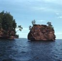
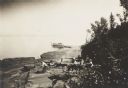
| Date: | 08 1971 |
|---|---|
| Description: | View across water towards two rock formations on the coast of Stockton Islands. |
If you didn't find the material you searched for, our Library Reference Staff can help.
Call our reference desk at 608-264-6535 or email us at: