 Search: increase
Search: lapham
Filter: Categories of Wisconsin Historical Images
Search: increase
Search: lapham
Filter: Categories of Wisconsin Historical Images
| Date: | 1867 |
|---|---|
| Description: | Carte-de-visite portrait of B.K. Emerson (1837-1928), professor of Minerology and Geology at Amherst College. Handwritten inscription at the bottom reads, ... |
| Date: | 1866 |
|---|---|
| Description: | Vignetted carte-de-visite portrait of James Hall (1811-1898), American geologist and paleontologist. Thought to be the top American invertebrate paleontol... |
| Date: | 1865 |
|---|---|
| Description: | Carte-de-visite portrait of Édouard Desor (1811-1882), Swiss geologist and professor at Neuchâtel academy. He chiefly studied the structure of glaciers an... |

| Date: | 1867 |
|---|---|
| Description: | Map of the entire state indicates county boundaries outlined in red, cities of over 3000 inhabitants and county seats. It also marks rivers and lakes. |

| Date: | 1850 |
|---|---|
| Description: | Mid and southern Wisconsin counties, city/town lines, lead mines, copper mines, streams, plank roads, and the Milwaukee and Mississippi Rail Roads. |

| Date: | 1863 |
|---|---|
| Description: | Includes index to public buildings, churches, schools. Inset: Glidden & Lockwood’s addition. Gives names of some property owners. |

| Date: | 1848 |
|---|---|
| Description: | This map shows lot and block numbers, roads, railroads, and some landowners’ names. Lake Michigan, the Milwaukee River, and the Menomonee River are labeled... |
| Date: | 1869 |
|---|---|
| Description: | Carte-de-visite portrait photograph of Hubert Anson Newton (1830-1896), American astronomer and mathematician. He was best known for his research on meteor... |

| Date: | 1869 |
|---|---|
| Description: | Carte-de-visite portrait of Henry B. Nason (1831-1895), head of the Chemistry department at the Rensselaer Polytechnic Institute, the first Technological s... |
| Date: | 1869 |
|---|---|
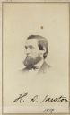
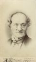
| Description: | Carte-de-visite portrait of Richard Owen (1804-1892), English comparative anatomist, and paleontologist. A controversial figure, Owen is credited for coini... |
| Date: | |
|---|---|
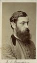
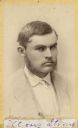
| Description: | Carte-de-visite portrait of Moses Strong, a Wisconsin archaeologist who served as Lapham's assistant. His most important article was titled, "Prehistoric M... |
| Date: | 1864 |
|---|---|
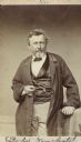
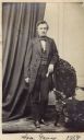
| Description: | Full-length carte-de-visite portrait of Asa Gray (1810-1888), American botanist. His most popular botanical publication, "Gray's Manual," remains a standar... |
| Date: | 1902 |
|---|---|
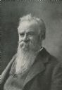
| Description: | Waist-up studio portrait, with accompanying obituary entry, of Major John Wesley Powell (1834-1902), American soldier, explorer, and geologist. Best known ... |
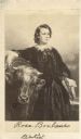
| Date: | |
|---|---|
| Description: | Carte-de-visite portrait, reproduced from a painting by Louis-Edouard Debufe, depicting French Artist Rosa Bonheur (1822-1899). This painting depicts the a... |
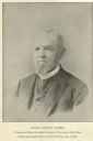
| Date: | 1892 |
|---|---|
| Description: | Portrait of Daniel Steele Durrie (1819-1892), American librarian. Durrie served as the librarian for the State Historical Society of Wisconsin (now the Wi... |
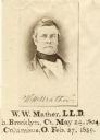
| Date: | |
|---|---|
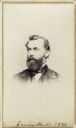
| Description: | Reproduction of a vignetted carte-de-visite portrait of William W. Mather (1804-1859), geologist and U.S. Army officer. Ohio's first state geologist. Capti... |

| Date: | 1865 |
|---|---|
| Description: | Map showing the location of meteorological stations and effects that Lake Michigan has had on Wisconsin temperatures in January and July. The map shows cou... |

| Date: | 1855 |
|---|---|
| Description: | This map shows counties, cities, rivers, canals, lakes, railroads, common roads, county towns, townships, villages, and post offices. The map includes part... |

| Date: | 1865 |
|---|---|
| Description: | This map shows the population density per square mile in the entire state, showing southeastern and southern Wisconsin had the greatest population density ... |

| Date: | 1874 |
|---|---|
| Description: | This map of Wisconsin shows cities, counties, railroads already completed and railroads projected, and geological makeup of the land such as lakes. |
If you didn't find the material you searched for, our Library Reference Staff can help.
Call our reference desk at 608-264-6535 or email us at: