 Search: increase
Search: lapham
Filter: Categories of Wisconsin Historical Images
Search: increase
Search: lapham
Filter: Categories of Wisconsin Historical Images

| Date: | 1828 |
|---|---|
| Description: | Map of the Louisville and Portland Canal on the Ohio River. The map shows Louisville, Shippingsport, Clarksville, Jeffersonville, Gravel Island, Corn Islan... |

| Date: | 07 1870 |
|---|---|
| Description: | This map of Ironton is pen-and-ink on paper and shows lots and block numbers, mill, foundry buildings, limestone quarry, iron mine, and roads. Relief is sh... |

| Date: | 1869 |
|---|---|
| Description: | This map shows lot and block numbers, some property ownership, wards, roads, and railroads and includes inset map of Glidden & Lockwood’s addition. There a... |

| Date: | 1868 |
|---|---|
| Description: | This map shows the configurations of the counties, communities, railroads and projected railroads, mines, shipping routes, and labeled rivers and lakes. Po... |

| Date: | 1867 |
|---|---|
| Description: | This pen and ink map shows counties outlined in red, cities over 3,000 inhabitants, and county seats. The bottom margin includes a handwritten description ... |
| Date: | 1864 |
|---|---|
| Description: | Carte-de-visite portrait of Jean Louis Rodolphe Agassiz (1807-1873), Swiss-born American zoologist, geologist and glaciologist. Founded the Museum of Compa... |
| Date: | 1869 |
|---|---|
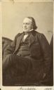
| Description: | Carte-de-visite portrait of Edward Hitchcock (1793-1864), American educator and geologist. Hitchcock served as the third president of Amherst College from ... |
| Date: | 1865 |
|---|---|
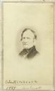
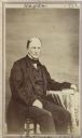
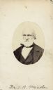
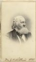
| Description: | Carte-de-visite portrait of Benjamin Silliman (1779-1864), notable American professor of science. He served for many years as a professor of Chemistry and ... |
| Date: | 1873 |
|---|---|
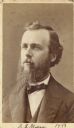
| Description: | Carte-de-visite portrait of Edward S. Morse (1838-1925), American zoologist and orientalist. As a zoologist, he discovered that brachiopods are worms rathe... |
| Date: | 1862 |
|---|---|
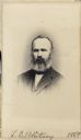
| Description: | Carte-de-visite portrait of Albert D. Hager (1817-1888), assistant state geologist for the Vermont state geological survey at the time of this photograph. ... |
| Date: | 1864 |
|---|---|
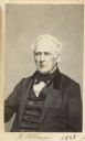
| Description: | Carte-de-visite portrait of Josiah D. Whitney (1819-1896), professor of Geology at Harvard University (1865-96), and chief of the Californa Geological Surv... |
| Date: | 1869 |
|---|---|
| Description: | Vignetted carte-de-visite portrait of William Marriott Canby (1831-1904), American botanist and businessman. Canby involved himself in many diverse endeavo... |
| Date: | 1869 |
|---|---|
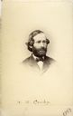
| Description: | Carte-de-visite portrait of John L. Russell (1808-1873), Botanist. From 1831-1854, Russell served as a Unitarian minister in a number of cities. Served as... |
| Date: | |
|---|---|
| Description: | Carte-de-visite portrait of Dr. Samuel Barnum Mead (1799-1880), Illinois-based physician and botanist. Mead, a pioneer in both the fields of medicine and b... |
| Date: | 1869 |
|---|---|
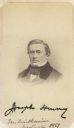
| Description: | Vignetted carte-de-visite portrait of Joseph Henry (1797-1878), Scottish-American scientist. Widely considered one of the greatest scientists of his genera... |
| Date: | 1866 |
|---|---|
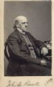
| Description: | Vignetted carte-de-visite of Dr. Jared Potter Kirtland (1793-1877), American scientist. Kirtland, among many other exploits, worked on the 1837 Ohio geolog... |
| Date: | 1865 |
|---|---|
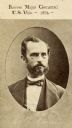
| Description: | Reproduction of a carte-de-visite portrait of Manning Ferguson Force (1824-1899), U.S. Army Commander. Force led the 20th Ohio Volunteer Infantry in the Un... |

| Date: | 1856 |
|---|---|
| Description: | This map show the surveyed southern part of state and includes "profile of the Milwaukee and Mississippi Rail Road." Counties are shown in pink, green, blu... |

| Date: | 1849 |
|---|---|
| Description: | A hand-drawn map of showing the two proposed routes from the Milwaukee River to the Moody’s Lime Quarry at Milwaukee, Wisconsin. The map includes the route... |

| Date: | 1854 |
|---|---|
| Description: | Reproduction printed on glossy, cloth-backed paper. Right side includes "References," or points of interest that correspond to numbers on the map. Running ... |
If you didn't find the material you searched for, our Library Reference Staff can help.
Call our reference desk at 608-264-6535 or email us at: