 Search: increase
Search: lapham
Filter: Categories of Wisconsin Historical Images
Search: increase
Search: lapham
Filter: Categories of Wisconsin Historical Images

| Date: | 1869 |
|---|---|
| Description: | Increase A. Lapham in the foreground of a rock formation in Taylor's Glen, with A. Holly sitting on a rock in the background. |
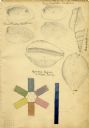
| Date: | 1828 |
|---|---|
| Description: | Increase Lapham's drawings of Unio plicatus and Unio radiatum (?) from the Scioto River, Cypraea tigris (Tiger cowry), and an Atlantic... |

| Date: | 12 22 1830 |
|---|---|
| Description: | Increase Lapham's drawing of the geological profile between the Sandusky plains and Portsmouth, Ohio. |
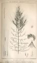
| Date: | 1854 |
|---|---|
| Description: | Increase Lapham's drawing of Zizania aquatica. The plant's common name is Northern Wild Rice. |
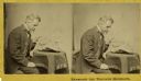
| Date: | 1868 |
|---|---|
| Description: | Stereograph of Increase Lapham examining a fragment of a meteorite. |

| Date: | 1849 |
|---|---|
| Description: | Handwritten list of plants in the Ranunculaceae or crowfoot family. |
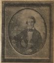
| Date: | |
|---|---|
| Description: | Newspaper photograph of a daguerreotype portrait of Increase Lapham taken in 1849. |
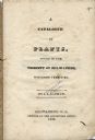
| Date: | 1838 |
|---|---|
| Description: | Title page of Increase Lapham's Catalog of Plants Found in the vicinity of Milwaukee, Wisconsin Territory. |
| Date: | 1832 |
|---|---|
| Description: | Page from the handwritten index to Lapham's Notes and accounts of canals, particularly the Ohio Canal near Portsmouth, 1830-1832. |
| Date: | 1845 |
|---|---|
| Description: | Page from Increase Lapham's 1845 list of plants of Wisconsin including Oxalidaceae, Zanthoxylaceae, and Anacardiaceae and notations of where and when indiv... |

| Date: | 1833 |
|---|---|
| Description: | Increase Lapham's plan for the canal terminus on Portsmouth Point at the confluence of the Scioto and Ohio Rivers. |

| Date: | 1863 |
|---|---|
| Description: | Ninth plate ambrotype of Anne Marie Alcott Lapham (Mrs. Increase A. Lapham). Waist-up portrait, facing slightly right, hands folded in lap, wearing a dress... |

| Date: | |
|---|---|
| Description: | Map showing Indian mounds in Milwaukee's Second Ward from a sketch made by Increase Lapham in 1836. Streets shown on the map include 6th Street, 5th Street... |

| Date: | 1828 |
|---|---|
| Description: | Increase Lapham's drawing and description of an earth borer for his handwritten manuscript, Notes and Accounts of Canals, Particularly the Ohio Canal Ne... |

| Date: | 1875 |
|---|---|
| Description: | This manuscript map by Increase Lapham, drawn in the last year of his life, shows landownership, roads and railroads, springs, and boat houses around Ocono... |

| Date: | 1840 |
|---|---|
| Description: | This manuscript map by Increase Lapham shows the railroads, roads, wetlands, lakes and streams, dams, prairies, and settlers in the eastern half of Waukesh... |
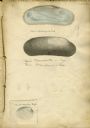
| Date: | 1828 |
|---|---|
| Description: | Increase Lapham's drawing of a Union mondonta (or Unio soleniformis) shell. There are also two views of another shell drawn below and a drawi... |
| Date: | 1850 |
|---|---|
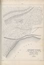
| Description: | A drawing of ancient works at the southeast angle of the Third Lake. |

| Date: | 1850 |
|---|---|
| Description: | Diagrams of four effigy mounds surveyed by Increase A. Lapham and W.H. Canfield in 1850. No. 1 is an unidentified animal shape, No. 2 consists of two linea... |
If you didn't find the material you searched for, our Library Reference Staff can help.
Call our reference desk at 608-264-6535 or email us at:
