 Search: indians
Search: menominee
Filter: Categories of Wisconsin Historical Images
Search: indians
Search: menominee
Filter: Categories of Wisconsin Historical Images
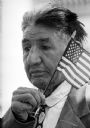
| Date: | 05 30 1961 |
|---|---|
| Description: | World War I veteran Edward J. Starr watches the Memorial Day service at the State Capitol while holding a small American flag. He is from a Menominee India... |
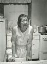
| Date: | 11 26 1970 |
|---|---|
| Description: | A candid portrait of Olivia King in her kitchen at their home on Rabbit Ridge on the Menominee reservation. |
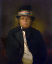
| Date: | |
|---|---|
| Description: | Chief Oshkosh, (1795-) August 29, 1858, Menomonee Indian chief. |

| Date: | 1860 |
|---|---|
| Description: | A survey map of Wisconsin, southeastern Minnesota, and northern Iowa, showing the status of surveys, rivers, and lakes. The map also shows the locations of... |

| Date: | 1933 |
|---|---|
| Description: | This map shows the township and range system, sections, cities and villages, schools, roads, railroads, and lakes and streams in Shawano County, which at t... |
| Date: | 1845 |
|---|---|
| Description: | Ke-wah-ten or "The North Wind," sister to Iwa-toke, "The Serpent." |
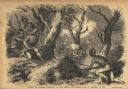
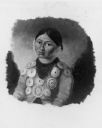
| Date: | 01 07 1855 |
|---|---|
| Description: | Sketch of the defeat of General Braddock during an ambush in the French and Indian War. Caption reads: "Defeat of General Braddock, in the French and India... |
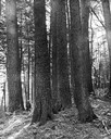
| Date: | |
|---|---|
| Description: | White pines on the Menominee Reservation. A man is standing next to the trees on the left-hand side of the image. |

| Date: | 1930 |
|---|---|
| Description: | This map shows rivers, lakes, trails, Indian villages, distances, and boundaries of tracts ceded by the Munnomonee, Winnebaygoes, and New York Indians Trib... |

| Date: | 1840 |
|---|---|
| Description: | This map is pencil on paper and shows rivers, granite locations, and selected landmarks. Relief is shown by hachures. |

| Date: | 1902 |
|---|---|
| Description: | This map shows the railroads of southern Wisconsin with the routes of the Chicago, Milwaukee, and St. Paul Railway traced in red. The township grid, counti... |

| Date: | 1979 |
|---|---|
| Description: | A map of Southern Wisconsin and northern Illinois showing the areas inhabited by the Ho-Chuck, formerly known as the Winnebago. Some of the location names ... |
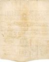
| Date: | 08 18 1821 |
|---|---|
| Description: | Green Bay Treaty, August 18, 1821. The treaty is signed by the chiefs of the six Indian nations for the possession of lands near the Fox River to the Winne... |
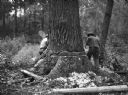
| Date: | 07 1936 |
|---|---|
| Description: | Two men are working together to cut down a large white pine tree on a Menominee Indian reservation. |

| Date: | 1846 |
|---|---|
| Description: | A map of Wisconsin and a portion of Minnesota that show the township surveys in progress in portions of the Saint Croix River region and in central Wiscons... |

| Date: | 1848 |
|---|---|
| Description: | Map of Wisconsin and a portion of Minnesota showing the township surveys in progress in portions of the Saint Croix River region and in central Wisconsin a... |

| Date: | 1874 |
|---|---|
| Description: | This hand-colored map shows the railroads "completed" "in progress" and "contemplated" rivers, counties, cities and villages, and named towns in the state,... |
| Date: | 1909 |
|---|---|
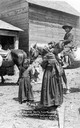
| Description: | A group of four Native American children thought to have been photographed at the Menominee Reservation. This image is part of an exhibit about Native Amer... |
| Date: | 1975 |
|---|---|
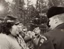
| Description: | Negotiations between Neil Hawpetoss, a leader of the Menominee Warrior Society that had seized the Alexian Novitiate at Gresham in January 1975, and a memb... |
| Date: | 10 07 1914 |
|---|---|
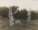
| Description: | Sara (Mrs. Joseph) Mallon (Menominee) of Milwaukee, wearing a sash stands between two American flags behind a memorial that reads, "Indian Mounds: One of s... |
If you didn't find the material you searched for, our Library Reference Staff can help.
Call our reference desk at 608-264-6535 or email us at: