 Search: menominee
Filter: Community of Milwaukee
Search: menominee
Filter: Community of Milwaukee
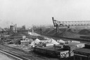
| Date: | 1940 |
|---|---|
| Description: | An industrial area of Milwaukee known as Menominee Valley. |
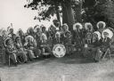
| Date: | |
|---|---|
| Description: | A group portrait of a band of Menominee Indians posing with their instruments. They are wearing feather headdresses. |
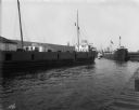
| Date: | 07 25 1914 |
|---|---|
| Description: | The Gilchrist Transportation Company cargo ship "Tyrone" transports coal on the Menominee River. |
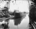
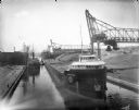
| Date: | 07 17 1914 |
|---|---|
| Description: | Steamboat "E.L. Wallace" on the Menominee River looking east from the 16th Street viaduct. Coal yards are on the banks of the harbor. |
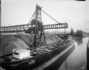
| Date: | 1919 |
|---|---|
| Description: | A large, coal cargo ship docks in the harbor in Menominee Valley. |
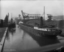
| Date: | 08 09 1914 |
|---|---|
| Description: | Erie Railroad Lake Line cargo ships transport coal on the Menominee River, west of the Water Street Bridge. |
| Date: | 07 17 1914 |
|---|---|
| Description: | Menominee River coal yards, west from the 16th Street viaduct. There is a cargo ship called the "John B. Cowle" in the harbor between two coal yards. Worke... |

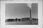
| Date: | 1942 |
|---|---|
| Description: | This photostat map shows roads, ferry, impassible marsh land, the Menominee River, the Milwaukee River, and Lake Michigan. |

| Date: | 08 27 1910 |
|---|---|
| Description: | Looking south towards the 16th Street viaduct over Menominee Valley from about Clybourn Street. Shows the surrounding industrial area and neighborhoods. Se... |

| Date: | 2000 |
|---|---|
| Description: | This map shows the industrial area along the Menominee River and canals. Industrial buildings are shown in orange and labeled in red. Other areas are shown... |

| Date: | 1862 |
|---|---|
| Description: | Drawn the second year of the Civil War, this 1862 map of Milwaukee shows post offices, light houses, beacon lights, county buildings, elevator warehouses, ... |
| Community: | Milwaukee |
|---|---|
| County: | Milwaukee |
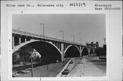
| Historic Name: | GRAND AVENUE VIADUCT |
| Reference Number: | 27219 |
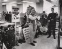
| Date: | 04 26 1971 |
|---|---|
| Description: | Led by James White, president of DRUMS, members of the organization and sympathizers staged a protest Monday at the First Wisconsin National Bank, 743 N. W... |

| Community: | Milwaukee |
|---|---|
| County: | Milwaukee |
| Historic Name: | |
| Reference Number: | 16312 |

| Fur Trader, Land Speculator, Politician and Founder of Milwaukee |
|---|
| Brief biography of Solomon Juneau, the fur trader, land speculator and politician who helped found Milwaukee. |
| Community: | Milwaukee |
|---|---|
| County: | Milwaukee |
| Historic Name: | JONES ISLAND SEWAGE TREATMENT PLANT |
| Reference Number: | 27225 |
| Community: | Milwaukee |
|---|---|
| County: | Milwaukee |
| Historic Name: | STANDARD PAPER CO. WAREHOUSE |
| Reference Number: | 29154 |
| History of Milwaukee, Wisconsin |
|---|
| Discover historical details and explore our online collections related to Milwaukee, Wisconsin. |
| Read about the possible historic origins of the frequently used syllable "wau" in the geographic names of Wisconsin. |
If you didn't find the material you searched for, our Library Reference Staff can help.
Call our reference desk at 608-264-6535 or email us at: