 Search: spooner
Filter: Community of Spooner
Filter: Type of Map or Atlas
Search: spooner
Filter: Community of Spooner
Filter: Type of Map or Atlas
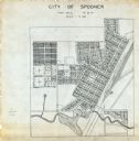
| Date: | 1900 |
|---|---|
| Description: | This map is ink on tracing paper and shows the city of Spooner. The map shows numbered plats, labeled streets, and the Yellow River. |

| Date: | 1941 |
|---|---|
| Description: | This 1941 map covers Washburn County, Wisconsin, as well as western Sawyer, eastern Burnett, and northeastern Polk counties. It shows the locations of tour... |
If you didn't find the material you searched for, our Library Reference Staff can help.
Call our reference desk at 608-264-6535 or email us at: