 Filter: Categories of Wisconsin Historical Images
Filter: Subject of Inland water transportation
Filter: Categories of Wisconsin Historical Images
Filter: Subject of Inland water transportation

| Date: | 1875 |
|---|---|
| Description: | This map, from G.K. Warren's 1876 Report on the transportation route along the Wisconsin and Fox Rivers in the State of Wisconsin between the Mississippi R... |

| Date: | 1875 |
|---|---|
| Description: | One of a set of maps from G.K. Warren's 1876 Report on the transportation route along the Wisconsin and Fox rivers in the State of Wisconsin between the Mi... |

| Date: | 1887 |
|---|---|
| Description: | Map of the Fox and Wisconsin Rivers to accompany Reuben Gold Thwaites' Historic Waterways. |
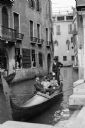
| Date: | 1906 |
|---|---|
| Description: | Mary E. Smith, seated on the right, riding a gondola ride with two friends in Venice, Italy. |

| Date: | 1909 |
|---|---|
| Description: | Photographic postcard across water, showing launch owned by Schlitz Brewery of Milwaukee operating on Stone Lake. Caption reads: "Stone Lake, Crandon, Wis.... |

| Date: | 1910 |
|---|---|
| Description: | Colorized postcard of logs floating in river, looking east between falls and railroad bridge. In the upper right corner is a large number of logging pylons... |

| Date: | |
|---|---|
| Description: | Aerial photograph of the Port of Kenosha and factories, with snow on the ground. There are four ships along the shoreline, and multiple factories on either... |

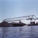
| Date: | 1945 |
|---|---|
| Description: | Port of Kenosha Transit Warehouse No. 1. There are two ships on the right side, one named "Broom Park." Three men are loading a car onto the ship using a c... |

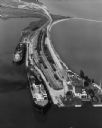
| Date: | 06 14 1961 |
|---|---|
| Description: | Aerial view of North and South Harbor Tracts, looking north from South Pier No. 2. There are skyscrapers in the background. there are multiple items of mac... |

| Date: | 08 1927 |
|---|---|
| Description: | A description of this photograph provided by Ernst Schmidt reads: "The government river inspection boat with the 'Mystery' tied to her and the 'Bottoms Up'... |

| Date: | 1776 |
|---|---|
| Description: | Map of the Delaware Bay, River, their shoreline, made to aid ships in navigating to Philadelphia. It is oriented with north to the right and shows inlets, ... |

| Date: | 1935 |
|---|---|
| Description: | This colored road map comes with a map legend and explanation, as well as an index of cities and towns (and their populations) in Wisconsin. Information ab... |

| Date: | 1936 |
|---|---|
| Description: | This colored road map shows automobile roads in Wisconsin as well as portions of nearby states. U.S. numbered highways are shown in red, and information ab... |

| Date: | |
|---|---|
| Description: | View across water towards a cargo ship at dock in front of large grain elevators. |
| Date: | |
|---|---|
| Description: | View across water towards the cargo ship "Henry LaLiberte" sitting in a loading dock under a cargo crane. |

| Date: | |
|---|---|
| Description: | View down concrete pier towards people and a docked ferry, the "C.G. Richter," waiting for the ferry to unload a car. |
| Date: | 09 17 1948 |
|---|---|
| Description: | Aerial view of two Lake Michigan ferries tied up at harbor slips. The eastern terminus of the Green Bay Route was the Lake Michigan port city of Kewaunee. ... |
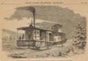
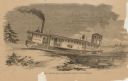
| Date: | 1859 |
|---|---|
| Description: | Engraved drawing of Norman Wiard's ice locomotive, the Lady Franklin operating on a frozen river. Male passengers and crew members are standing on t... |
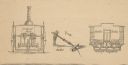
| Date: | 1859 |
|---|---|
| Description: | Cutaway details of Norman Wiard's ice locomotive, Lady Franklin sowing the stern and seating area. Also included is a drawing of the vehicle's ancho... |
| Date: | 1859 |
|---|---|
| Description: | Engraved drawing of Norman Wiard's ice locomotive, Lady Franklin leaving a snowy riverbank and entering the frozen river. The vessel was built, but ... |
If you didn't find the material you searched for, our Library Reference Staff can help.
Call our reference desk at 608-264-6535 or email us at: