 Filter: Subject of revolution, 1775-1783
| Date: | 06 14 1928 |
|---|---|
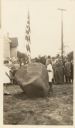
| Description: | The Aupaumut Memorial Tablet unveiling ceremony. The memorial is for Captain Hendrick Aupaumut, a Revolutionary War soldier, born 1757, died 1830. The tabl... |
| Date: | 06 14 1928 |
|---|---|
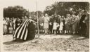
| Description: | The Aupaumut Memorial Tablet unveiling ceremony. The memorial is for Captain Hendrick Aupaumut, a Revolutionary War soldier, born 1757, died 1830. The tabl... |
| Date: | 1860 |
|---|---|
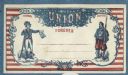
| Description: | An intricate design. A blue line frames a background of red horizontal stripes. Inside an ornate border, two figures stand on the left and right. The left ... |
| Date: | |
|---|---|
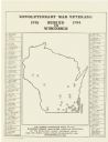
| Description: | A map of Wisconsin showing the gravesite locations of the 43 Revolutionary War soldiers buried in state, surrounding the map are the names and in some inst... |
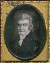
| Date: | 1850 |
|---|---|
| Description: | Ninth plate daguerreotype of a painted quarter-length portrait of Felix Walker, 1793-1828. Mr. Walker fought in the Revolutionary War alongside Daniel Boon... |
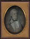
| Date: | 1850 |
|---|---|
| Description: | Quarter plate daguerreotype of a painting of General William Irvine. The portrait shows General Irvine in his military uniform. General Irvine served as a ... |
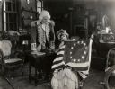
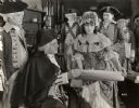
| Date: | 1917 |
|---|---|
| Description: | General George Washington, played by George MacQuarrie, looks on as Betsy Ross (Alice Brady) shows him the American flag she has been sewing. This is a sce... |
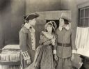
| Date: | 1917 |
|---|---|
| Description: | George Washington's aide Joseph Ashburn (played by John Bowers in Revolutionary War uniform) confronts Clarence Vernon (Frank Mayo) who has been hiding in ... |
| Date: | 1917 |
|---|---|
| Description: | General George Washington (played by George McQuarrie) examines a document presented by Betsy Ross (Alice Brady). Over her left shoulder, in the role of Jo... |
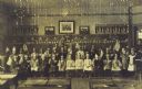
| Date: | |
|---|---|
| Description: | Group portrait of class of young students holding American flags posed at the front of a classroom. Their teacher is standing on the far right, and desks a... |

| Date: | |
|---|---|
| Description: | Sixth plate ambrotype of a painting of Captain Samuel Murphy. Murphy served with Captain Samuel Brady in the Pittsburgh region during the Revolutionary War... |

| Date: | 08 31 1779 |
|---|---|
| Description: | A handwritten "list of different inhabitants that consented to furnish the troops belonging to the state of Virginia." |

| Date: | 1783 |
|---|---|
| Description: | This map is hand-colored and shows the boundaries of British, Spanish, and the newly recognized American claims, as well as the fishing rights granted to F... |

| Date: | 1776 |
|---|---|
| Description: | Map of the American colonies and land east of the Mississippi River. Prominent cities, forts, Native American land, mountains, rivers and lakes are all sho... |

| Date: | 1777 |
|---|---|
| Description: | Map of Colonial America east of Lake Michigan showing regions, cities, forts, Native American land, mountains, lakes, and rivers. Crossed swords and small ... |

| Date: | 1780 |
|---|---|
| Description: | Detailed map of America east of the Louisiana region. It shows forts, cities, borders and boundary lines, Native American land, the post road, mountains, w... |

| Date: | 02 04 1783 |
|---|---|
| Description: | One of the first and few maps to attempt to map the new boundaries of the United States and British territories during the preliminary treaty at the end of... |

| Date: | 1780 |
|---|---|
| Description: | Detailed topographical and political map of the area from Lake Champlain to Albany and the Hudson River. Relief is shown through hachures. The map shows ci... |

| Date: | 10 1776 |
|---|---|
| Description: | Broadside map showing the British invasion of New York city in August and September of 1776. The map shows important cities, forts, roads, hills, mountains... |
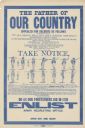
| Date: | 1917 |
|---|---|
| Description: | Poster featuring a reproduction of a Revolutionary War notice calling for soldiers. In addition to its text, this includes illustrations of soldier's posit... |
If you didn't find the material you searched for, our Library Reference Staff can help.
Call our reference desk at 608-264-6535 or email us at: