Twenty Five Miles of Industrial Tour Wholly Within the City Limits of Superior Wisconsin | Map or Atlas | Wisconsin Historical Society

Map or Atlas

Twenty Five Miles of Industrial Tour Wholly Within the City Limits of Superior Wisconsin

Twenty Five Miles of Industrial Tour Wholly Within the City Limits of Superior Wisconsin | Map or Atlas | Wisconsin Historical Society
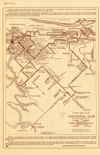
This map shows industrial points of interest in Superior. The top of the map reads: "Superior, Douglas County, Wisconsin, as this Industrial Tour map indicates, is beautifully situated and very secure, in its strategic position at the Head of America's greatest inland waterway system, the great Lakes. People, together with capital, industry and commerce, make Cities. It is merely a matter of a short time until Superior will become the terminal of the great Lakes-St. Lawrence Waterway, binging the ocean two thousand miles inland to the richest, largest developed and undeveloped inland empire, any port in the world has ever or will ever serve." The bottom of the map reads: "Tributary to Superior is an unexcelled farming country, and vacation land, Douglas County, of which Superior is the County seat. Agriculturally, it is probably the fastest growing county in the State. The leading industry is dairying, which returns over two million dollars each year to the farmers. For those tourists who like to follow historic trails, and for the vacationist who seeks the quiet seclusion of lakes and streams, there is a never ending series of recreations and delights in Douglas County and the surrounding territory that Superior serves. It is in this hinterland that the camper and the fisherman find that for which their hearts have yearned. ASK FOR OUR SCENIC TOUR MAP." The map is printed in brown ink. The back of the map has a list of attractions on the tour including: ore, coal, dry, and merchandise docks, Door Catch Factory, a factory that manufactures "Colored, Flavored Toothpick," a co-operative dairy, a chair factory, fair grounds, a broadcasting station, railroad yards, a briquet plant, and grain elevators.
DESCRIPTION
This map shows industrial points of interest in Superior. The top of the map reads: "Superior, Douglas County, Wisconsin, as this Industrial Tour map indicates, is beautifully situated and very secure, in its strategic position at the Head of America's greatest inland waterway system, the great Lakes. People, together with capital, industry and commerce, make Cities. It is merely a matter of a short time until Superior will become the terminal of the great Lakes-St. Lawrence Waterway, binging the ocean two thousand miles inland to the richest, largest developed and undeveloped inland empire, any port in the world has ever or will ever serve." The bottom of the map reads: "Tributary to Superior is an unexcelled farming country, and vacation land, Douglas County, of which Superior is the County seat. Agriculturally, it is probably the fastest growing county in the State. The leading industry is dairying, which returns over two million dollars each year to the farmers. For those tourists who like to follow historic trails, and for the vacationist who seeks the quiet seclusion of lakes and streams, there is a never ending series of recreations and delights in Douglas County and the surrounding territory that Superior serves. It is in this hinterland that the camper and the fisherman find that for which their hearts have yearned. ASK FOR OUR SCENIC TOUR MAP." The map is printed in brown ink. The back of the map has a list of attractions on the tour including: ore, coal, dry, and merchandise docks, Door Catch Factory, a factory that manufactures "Colored, Flavored Toothpick," a co-operative dairy, a chair factory, fair grounds, a broadcasting station, railroad yards, a briquet plant, and grain elevators.
RECORD DETAILS
Image ID:103433
Creation Date:circa 1934
Creator Name:Superior (Wis.) Association of Commerce
City:Superior
County:Douglas
State:Wisconsin
Collection Name:Map Collection
Genre:Map or Atlas
Original Format Type:
Original Format Number:
Original Dimensions:
ADDITIONAL INFORMATION
To view the entire map see Maps and Atlases in Our Collections.
SUBJECTS
Cities and towns
Factories
Railroad tracks
Railroad yards
Streets
Rivers
Superior, Lake
Land
Farms
Great Lakes

How to Purchase a Copy

Buy The Image

For commercial or non-profit use, please contact Image Sales.

By clicking "BUY" you agree to our Terms of Use.

10-percent discount for Society Members.

Image-purchasing questions? Please Contact Us.

RIGHTS AND PERMISSIONS
This image is issued by the Wisconsin Historical Society. Use of the image requires written permission from the staff of the Collections Division. It may not be sold or redistributed, copied or distributed as a photograph, electronic file, or any other media. The image should not be significantly altered through conventional or electronic means. Images altered beyond standard cropping and resizing require further negotiation with a staff member. The user is responsible for all issues of copyright. Please Credit: Wisconsin Historical Society.
Reference Details
Location:Wisconsin Historical Society Archives, 4th Floor, Madison, Wisconsin

How to View in Person

To view this image, visit the Archives Research Room on the 4th floor at the Society Headquarters building in Madison, WI. Print out this index page and present it to the librarian. Use the links below to plan your visit to the Society's Archives.

Checking Out Materials

Visual materials in the Archives do not circulate and must be viewed in the Society's Archives Research Room.

How to Cite

For the purposes of a bibliography entry or footnote, follow this model:

Wisconsin Historical Society Citation
Wisconsin Historical Society, Creator, Title, Image ID. Viewed online at (copy and paste image page link).
Wisconsin Center for Film and Theater Research Citation
Wisconsin Center for Film and Theater Research, Creator, Title, Image ID. Viewed online at (copy and paste image page link).

Have Questions?

Contact our Archives staff by email.