Map or Atlas
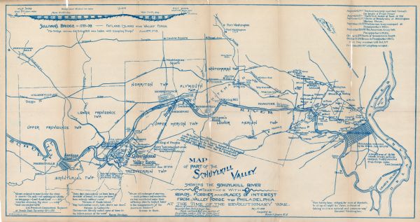
Map of Part of the Schuylkill Valley

| Map showing the Schuylkill River with roads, ferries, and points of interest from Valley Forge to Philadelphia, Pennsylvania as it appeared during the Revolutionary War. The map has detailed information about battles and skirmishes that took place along the route and features quotes along the top and bottom regarding various battles. The top right of the map features a timeline of events between August 24th and December 19th, 1777. The top left has a drawing of Sullivan's Bridge and Fatland Island. The Delaware River is also labeled. |
| Image ID: | 110967 |
|---|---|
| Creation Date: | 05 01 1899 |
| Creator Name: | Smith, Edwin F. |
| City: | |
| County: | |
| State: | Pennsylvania |
| Collection Name: | Map Collection |
| Genre: | Map or Atlas |
| Original Format Type: | prints, photomechanical |
| Original Format Number: | F 157 M7 H57 V. 4 |
| Original Dimensions: | unknown |
| Historical Society of Montgomery County Pennsylvania Sketches Vol. 4, 1910 |
| Cities and towns |
| Islands |
| Battlefields |
| Battles |
| American Revolution (United States : 1775-1783) |
| War |
| Flags |
| Bridges |
| Ferries |
| Roads |
| Rivers |
| This image is issued by the Wisconsin Historical Society. Use of the image requires written permission from the staff of the Collections Division. It may not be sold or redistributed, copied or distributed as a photograph, electronic file, or any other media. The image should not be significantly altered through conventional or electronic means. Images altered beyond standard cropping and resizing require further negotiation with a staff member. The user is responsible for all issues of copyright. Please Credit: Wisconsin Historical Society. |
| Location: | Wisconsin Historical Society Archives, 4th Floor, Madison, Wisconsin |
|---|
