Map or Atlas
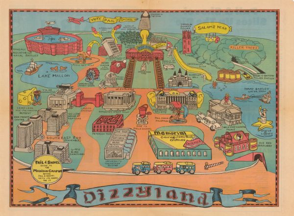
Pail & Shovel Guide to the Madison Campus After Pail & Shovel Gets Its Hands On It

| Map of the University of Wisconsin-Madison re-imagined as "Dizzyland", the campus taken over the by the student government party Pail and Shovel. The map shows many campus buildings and landmarks as they may have appeared at a carnival, each with a new name and purpose. Many of the illustrations tie into platform pledges of the Pail and Shovel Party, an admittedly absurdest party that had formed primarily as a joke. The party began campaigning in the spring 1978 student elections to convert the school budget into pennies to be dumped on Library Mall where students could use pails and shovels to take what they wished. The Party also promised to flood Camp Randall Stadium for mock naval battles, buy the Statue of Liberty and move it to Wisconsin. |
| Image ID: | 114685 |
|---|---|
| Creation Date: | circa 1979 |
| Creator Name: | Pail and Shovel Party. |
| City: | Madison |
| County: | Dane |
| State: | Wisconsin |
| Collection Name: | Edward Ben Elson papers, 1960-1983 |
| Genre: | Map or Atlas |
| Original Format Type: | prints, photomechanical |
| Original Format Number: | M2001-002 |
| Original Dimensions: | 23.5 x 16.5 inches |
| Student activities |
| University of Wisconsin |
| Political campaigns |
| Political parties |
| College buildings |
| Lakes |
| Caricatures and cartoons |
| This image is issued by the Wisconsin Historical Society. Use of the image requires written permission from the staff of the Collections Division. It may not be sold or redistributed, copied or distributed as a photograph, electronic file, or any other media. The image should not be significantly altered through conventional or electronic means. Images altered beyond standard cropping and resizing require further negotiation with a staff member. The user is responsible for all issues of copyright. Please Credit: Wisconsin Historical Society. |
| Location: | Wisconsin Historical Society Archives, 4th Floor, Madison, Wisconsin |
|---|
