Map or Atlas
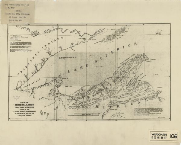
Map of the Mineral Lands Upon Lake Superior Ceded to the United States by the Treaty of 1842 With the Chippeway Indians

| This map shows lakes, rivers, Chippewa land, the U.S. Mineral Land Agency, boundary between U.S. and Canada, Methodist and Catholic missions, and American Fur Company locations. The Western half of Lake Superior, including parts of Michigan, Wisconsin, and Minnesota are covered. Relief is shown by hachures. The bottom right margin reads: "This map was compiled partly from explorations made in 1844 by the Mineral Land Agency at Copper Harbor, under instructions from the Hon. W. Wilkins, secretary of war, from information received from miners and other explorers, and partly from a map published by the ’Society for the Diffusion of Useful Knowledge’. Drawn under the direction of Genl. J. Stockton ..." The top left margin includes a mounted label that reads: Map accompanying report of A. B. Gray -1845- Senate Doc. 175, 28th Cong. 2d Sess., Vol. XI, Serial No. 461 doc no. 175." Bottom right margin includes a mounted label that reads: "Wisconsin exhibit 106." |
| Image ID: | 116582 |
|---|---|
| Creation Date: | 1845 |
| Creator Name: | Gray, A. B. (Andrew Belcher), 1820-1862. |
| City: | |
| County: | |
| State: | Wisconsin |
| Collection Name: | Map Collection |
| Genre: | Map or Atlas |
| Original Format Type: | prints, photomechanical |
| Original Format Number: | H GX909 1845 G |
| Original Dimensions: | 26 x 44 cm., on sheet 41 x 51 cm. |
| Accompanies: Report from the secretary of war, communicating (in compliance with a resolution of the 15th instant) a report of John Stockton, superintendent of the mineral lands on Lake Superior, with map, &c. March 19, 1845 ([Washington, D.C.], 1845). |
| Lakes |
| Rivers |
| Superior, Lake |
| Bays |
| Indigenous peoples, Wisconsin |
| Fur trade |
| Apostle Islands (Wis.) |
| Madeline Island (Wis.) |
| Missions |
| Indigenous peoples, Minnesota |
| Land companies |
| This image is issued by the Wisconsin Historical Society. Use of the image requires written permission from the staff of the Collections Division. It may not be sold or redistributed, copied or distributed as a photograph, electronic file, or any other media. The image should not be significantly altered through conventional or electronic means. Images altered beyond standard cropping and resizing require further negotiation with a staff member. The user is responsible for all issues of copyright. Please Credit: Wisconsin Historical Society. |
| Location: | Wisconsin Historical Society Archives, 4th Floor, Madison, Wisconsin |
|---|
