Map or Atlas
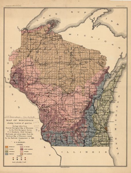
Map of Wisconsin : Showing Location of Quarries

| This map shows the location of quarries throughout the state. Original caption reads, "Geology taken from General Geological Map of Wisconsin by the First Geological Survey, T C. Chamberlin chief Geologist. Railroads and cities taken from the Railroad Map of Wisconsin issued by the Railroad Commissioner in 1896. By. E.R. Buckly." Cities, towns, lakes, rivers, and county boundaries are labeled. Included are portions of Michigan, Illinois, and Iowa. Lake Michigan is on the far right, with Lake Superior at the top. Includes a legend, depicting various geologic periods and quarries locations by color. |
| Image ID: | 119918 |
|---|---|
| Creation Date: | circa 1897 |
| Creator Name: | Buckley, E. R. (Ernest Robertson) |
| City: | |
| County: | |
| State: | Wisconsin |
| Collection Name: | Map Collection |
| Genre: | Map or Atlas |
| Original Format Type: | prints, fine-art |
| Original Format Number: | H GX902 1897 B |
| Original Dimensions: | 51 x 40 cm. on sheet 56 x 43 cm |
| Lakes |
| Cities and towns |
| Quarries and quarrying |
| Railroads |
| Superior, Lake |
| Michigan, Lake |
| Mississippi River |
| Rivers |
| This image is issued by the Wisconsin Historical Society. Use of the image requires written permission from the staff of the Collections Division. It may not be sold or redistributed, copied or distributed as a photograph, electronic file, or any other media. The image should not be significantly altered through conventional or electronic means. Images altered beyond standard cropping and resizing require further negotiation with a staff member. The user is responsible for all issues of copyright. Please Credit: Wisconsin Historical Society. |
| Location: | Wisconsin Historical Society Archives, 4th Floor, Madison, Wisconsin |
|---|
