Section of the Valley of the Mississippi River at Prairie du Chien | Map or Atlas | Wisconsin Historical Society

Map or Atlas

Section of the Valley of the Mississippi River at Prairie du Chien
Section of the Valley of the Mississippi River at Prairie du Chien | Map or Atlas | Wisconsin Historical Society
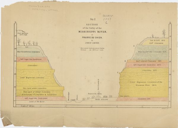
This map shows the geological makeup of the valley in red, yellow, and green, the Mississippi River, and the location of Fort Crawford. The geology on the left bluff from bottom up is: Soft Sugar-like Sandstone; Thin layer of Oolitic Limestone. Alterations of Limestone & Sandstone; Very hard white Limestone; Lower Magnesian Limestone; Limestones; Soft Sugar like Sandstone; Blue Fossiliferous Limestone; and soil. The geology of the right bluff from bottom up is: Sandstone 30ft.; Lower Magnesian Limestone of the Wisconsin River 190 ft.; Limestone 40 ft.; Soft Sugar-like Sandstone 40 ft.; Buff colored Limestone 20 ft.; Blue Fossiliferous Limestone 115 ft.; Soil & Cliff. 60 ft. Cliff Limestone.
DESCRIPTION
This map shows the geological makeup of the valley in red, yellow, and green, the Mississippi River, and the location of Fort Crawford. The geology on the left bluff from bottom up is: Soft Sugar-like Sandstone; Thin layer of Oolitic Limestone. Alterations of Limestone & Sandstone; Very hard white Limestone; Lower Magnesian Limestone; Limestones; Soft Sugar like Sandstone; Blue Fossiliferous Limestone; and soil. The geology of the right bluff from bottom up is: Sandstone 30ft.; Lower Magnesian Limestone of the Wisconsin River 190 ft.; Limestone 40 ft.; Soft Sugar-like Sandstone 40 ft.; Buff colored Limestone 20 ft.; Blue Fossiliferous Limestone 115 ft.; Soil & Cliff. 60 ft. Cliff Limestone.
RECORD DETAILS
Image ID:122990
Creation Date: 1839
Creator Name:Locke, John
City:Prairie du Chien
County:Crawford
State:Wisconsin
Collection Name:Map Collection
Genre:Map or Atlas
Original Format Type:prints, photomechanical
Original Format Number:H GX875 1839 L
Original Dimensions:18 x 31 cm, on sheet 25 x 35 cm
SUBJECTS
Cities and towns
Geology
Formations (Geology)
Fortification
Mississippi River
Valleys

How to Purchase a Copy

Buy The Image

For commercial or non-profit use, please contact Image Sales.

By clicking "BUY" you agree to our Terms of Use.

10-percent discount for Society Members.

Image-purchasing questions? Please Contact Us.

RIGHTS AND PERMISSIONS
This image is issued by the Wisconsin Historical Society. Use of the image requires written permission from the staff of the Collections Division. It may not be sold or redistributed, copied or distributed as a photograph, electronic file, or any other media. The image should not be significantly altered through conventional or electronic means. Images altered beyond standard cropping and resizing require further negotiation with a staff member. The user is responsible for all issues of copyright. Please Credit: Wisconsin Historical Society.
Reference Details
Location:Wisconsin Historical Society Archives, 4th Floor, Madison, Wisconsin

How to View in Person

To view this image, visit the Archives Research Room on the 4th floor at the Society Headquarters building in Madison, WI. Print out this index page and present it to the librarian. Use the links below to plan your visit to the Society's Archives.

Checking Out Materials

Visual materials in the Archives do not circulate and must be viewed in the Society's Archives Research Room.

How to Cite

For the purposes of a bibliography entry or footnote, follow this model:

Wisconsin Historical Society Citation
Wisconsin Historical Society, Creator, Title, Image ID. Viewed online at (copy and paste image page link).
Wisconsin Center for Film and Theater Research Citation
Wisconsin Center for Film and Theater Research, Creator, Title, Image ID. Viewed online at (copy and paste image page link).

Have Questions?

Contact our Archives staff by email.