Map or Atlas
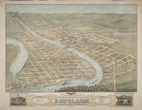
Bird's-Eye View of the City of Eau Claire, Wisconsin

| Birds-eye drawing of Eau Claire depicts street names and street locations, houses, trees, bridges, piers, canals, railroads, and the Chippewa and Eau Claire rivers. A reference key at the bottom of the map shows the locations of the city's courthouse, East Side Public School, West Side Public School, West Side Park, University Square, Railroad Depot, and specific denominational churches (Baptist, Presbyterian, Congregational, Baptist, Methodist, Lutheran, Roman Catholic, and Universalist). At the bottom left of the map is an inset street-view drawing of the West Side Public School, and at the bottom right of the map is an inset street-view drawing of the East Side Public School. |
| Image ID: | 12330 |
|---|---|
| Creation Date: | 1872 |
| Creator Name: | Brosius, H. |
| City: | Eau Claire |
| County: | Eau Claire |
| State: | Wisconsin |
| Collection Name: | Map Collection |
| Genre: | Map or Atlas |
| Original Format Type: | prints, photomechanical |
| Original Format Number: | D GX9029 E14 1872 B |
| Original Dimensions: | 27 x 22 inches |
| Church buildings |
| Trees |
| Schools |
| Cities and towns |
| Factories |
| Log transportation |
| Bird's-eye views |
| Hills |
| Islands |
| Bridges |
| Canals |
| Railroads |
| Roads |
| Ships |
| Dams |
| Rivers |
| This image is issued by the Wisconsin Historical Society. Use of the image requires written permission from the staff of the Collections Division. It may not be sold or redistributed, copied or distributed as a photograph, electronic file, or any other media. The image should not be significantly altered through conventional or electronic means. Images altered beyond standard cropping and resizing require further negotiation with a staff member. The user is responsible for all issues of copyright. Please Credit: Wisconsin Historical Society. |
| Location: | Wisconsin Historical Society Archives, 4th Floor, Madison, Wisconsin |
|---|
