Map or Atlas
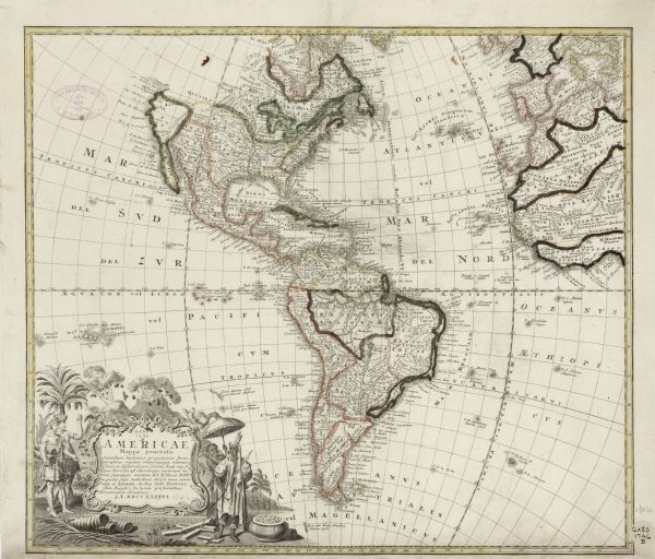
Americae Mappa Generalis: Secundum Legitimas Projectionis Stereographicae Regulas

| Detailed map of the western hemisphere and part of Africa and Europe. Islands, cities, settlements, rivers, lakes, countries, and regions are marked. Mountains appear pictorially, and hand-painted borders divide the various countries, territories, and regions. A few annotations appear throughout the map, particularly notes explaining who discovered certain features. Of particular interest, a note just above California marks a wide water access point into the interior of North America. This was, according to this map, discovered by Martin d'Aguilar, and is one of the many points cartographers and explorers hoped would lead to the North West Passage. The title cartouche features two erupting volcanoes, birds, palm trees, a pot of gold, and two groups of Native Americans. The group on the left hold bows and a shrunken head, while on the left a young man holds an umbrella over a robed man holding a spear. |
| Image ID: | 123692 |
|---|---|
| Creation Date: | 1746 |
| Creator Name: | Homann Erben (Firm) |
| City: | |
| County: | |
| State: | |
| Collection Name: | Map Collection |
| Genre: | Map or Atlas |
| Original Format Type: | prints, fine-art |
| Original Format Number: | H GX80 1746 B |
| Original Dimensions: | 47 x 54 cm., on sheet 50 x 58 cm |
| Men |
| Discovery and exploration |
| Lakes |
| Ocean |
| Rivers |
| Volcanoes |
| Clothing and dress |
| Cities and towns |
| Maps |
| Islands |
| Mountains |
| Birds |
| Engraving |
| Trees |
| This image is issued by the Wisconsin Historical Society. Use of the image requires written permission from the staff of the Collections Division. It may not be sold or redistributed, copied or distributed as a photograph, electronic file, or any other media. The image should not be significantly altered through conventional or electronic means. Images altered beyond standard cropping and resizing require further negotiation with a staff member. The user is responsible for all issues of copyright. Please Credit: Wisconsin Historical Society. |
| Location: | Wisconsin Historical Society Archives, 4th Floor, Madison, Wisconsin |
|---|
