A Map of the Whole Continent of America: Particularly Shewing the British Empire in the Northern Part of America, with the Divisions of the New Governments since the Accession of Canada and Florida | Map or Atlas | Wisconsin Historical Society

Map or Atlas

A Map of the Whole Continent of America: Particularly Shewing the British Empire in the Northern Part of America, with the Divisions of the New Governments since the Accession of Canada and Florida
A Map of the Whole Continent of America: Particularly Shewing the British Empire in the Northern Part of America, with the Divisions of the New Governments since the Accession of Canada and Florida | Map or Atlas | Wisconsin Historical Society
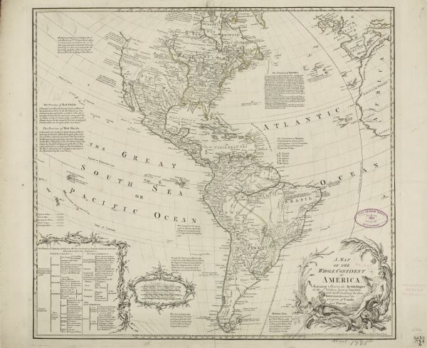
Map of North and South America, showing the boundaries of colonial territories, cities, settlements, rivers, lakes, and Native American land. Particular emphasis is given to the eastern half of North America, which is entirely marked as British territory. Numerous annotations and descriptive blocks of text appear throughout the map, adding interesting notes on the land, natives, discoveries, and the history of colonial claims. A small note next to California seeks to explain why many cartographers depicted it as an island ("being cover'd in the Spring Tides"). A table in the bottom left further divides the lands of North and South America into its colonial possessors. The title cartouche features cherubs wrestling with a net and fish, an alligator or crocodile, a beaver, and a nude Amazon queen holding a bow and a quiver of arrows.
DESCRIPTION
Map of North and South America, showing the boundaries of colonial territories, cities, settlements, rivers, lakes, and Native American land. Particular emphasis is given to the eastern half of North America, which is entirely marked as British territory. Numerous annotations and descriptive blocks of text appear throughout the map, adding interesting notes on the land, natives, discoveries, and the history of colonial claims. A small note next to California seeks to explain why many cartographers depicted it as an island ("being cover'd in the Spring Tides"). A table in the bottom left further divides the lands of North and South America into its colonial possessors. The title cartouche features cherubs wrestling with a net and fish, an alligator or crocodile, a beaver, and a nude Amazon queen holding a bow and a quiver of arrows.
RECORD DETAILS
Image ID:123703
Creation Date:circa 1780
Creator Name:Bowles, John
City:
County:
State:
Collection Name:Map Collection
Genre:Map or Atlas
Original Format Type:prints, fine-art
Original Format Number:H GX80 1785 B
Original Dimensions:50 x 55 cm., on sheet 53 x 65 cm
SUBJECTS
Alligators
Beavers
Fishes
Engraving
Nudes
Hats
Jewelry
Cities and towns
Maps
Writing
Islands
Women
International relations
Lakes
Rivers

How to Purchase a Copy

Buy The Image

For commercial or non-profit use, please contact Image Sales.

By clicking "BUY" you agree to our Terms of Use.

10-percent discount for Society Members.

Image-purchasing questions? Please Contact Us.

RIGHTS AND PERMISSIONS
This image is issued by the Wisconsin Historical Society. Use of the image requires written permission from the staff of the Collections Division. It may not be sold or redistributed, copied or distributed as a photograph, electronic file, or any other media. The image should not be significantly altered through conventional or electronic means. Images altered beyond standard cropping and resizing require further negotiation with a staff member. The user is responsible for all issues of copyright. Please Credit: Wisconsin Historical Society.
Reference Details
Location:Wisconsin Historical Society Archives, 4th Floor, Madison, Wisconsin

How to View in Person

To view this image, visit the Archives Research Room on the 4th floor at the Society Headquarters building in Madison, WI. Print out this index page and present it to the librarian. Use the links below to plan your visit to the Society's Archives.

Checking Out Materials

Visual materials in the Archives do not circulate and must be viewed in the Society's Archives Research Room.

How to Cite

For the purposes of a bibliography entry or footnote, follow this model:

Wisconsin Historical Society Citation
Wisconsin Historical Society, Creator, Title, Image ID. Viewed online at (copy and paste image page link).
Wisconsin Center for Film and Theater Research Citation
Wisconsin Center for Film and Theater Research, Creator, Title, Image ID. Viewed online at (copy and paste image page link).

Have Questions?

Contact our Archives staff by email.