Map or Atlas
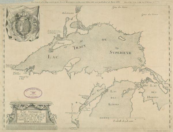
Lac Superieur et autres lieux ou sont les Missions des Peres de la Compagnie de Jesus comprises sous le nom D’outaouacs

| This map is in French and shows Lac Tracy ov Superieur (Lake Superior), Baye des Puans (Green Bay), and portions of Lac des Ilinois (Lake Michigan) and Lac des Hurons (Lake Huron). The top margin shows the French coat of arms. The bottom margin includes notes in English that reads: "Jesuit map of Lake Superior, from the "Relation" of 1670-71. Reproduced from Thwaites, Jesuit Relations, 1v, by courtesy of Burrows Brothers Co. Attributed to Jesuit father Claude Dablon and originally published in France as part of the Jesuit Relations. |
| Image ID: | 39791 |
|---|---|
| Creation Date: | 1670 |
| Creator Name: | Dablon, Claude, 1619-1697. |
| City: | |
| County: | |
| State: | Wisconsin |
| Collection Name: | Map Collection |
| Genre: | Map or Atlas |
| Original Format Type: | prints, photomechanical |
| Original Format Number: | H GX909 1670 J |
| Original Dimensions: | 20.25 x 15.5 inches |
| Land |
| Landforms |
| Great Lakes (North America) |
| Michigan, Lake |
| Superior, Lake |
| Signs and symbols |
| This image is issued by the Wisconsin Historical Society. Use of the image requires written permission from the staff of the Collections Division. It may not be sold or redistributed, copied or distributed as a photograph, electronic file, or any other media. The image should not be significantly altered through conventional or electronic means. Images altered beyond standard cropping and resizing require further negotiation with a staff member. The user is responsible for all issues of copyright. Please Credit: Wisconsin Historical Society. |
| Location: | Wisconsin Historical Society Archives, 4th Floor, Madison, Wisconsin |
|---|
