Photograph
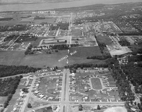
Aerial View of Midvale Neighborhood

| Aerial view looking north from near the city's southwestern limits in 1954. Shows text indicating Midvale Boulevard, Odana Road, Tokay Boulevard, Mineral Point Road, and University Avenue with Lake Mendota in the distance. |
| Image ID: | 4716 |
|---|---|
| Creation Date: | 06 07 1954 |
| Creator Name: | Newhouse, John |
| City: | Madison |
| County: | Dane |
| State: | Wisconsin |
| Collection Name: | John Newhouse photographs, interviews and other materials, 1945-1974 |
| Genre: | Photograph |
| Original Format Type: | photographic print, b&w |
| Original Format Number: | PH 144 (3) |
| Original Dimensions: | 11 x 14 inches |
| John Newhouse was a photographer for the Wisconsin State Journal in Madison, Wisconsin. The Society maintains his papers (1945-1974) which includes photographs and negatives of Madison locations, clippings of articles by Newhouse on local issues, especially Frank Lloyd Wright's Monona Terrace Project, the Monona Basin Project, city planning, and the Madison Public Housing Authority. |
| Roads |
| Cities and towns |
| Real estate development |
| Aerial photographs |
| Lakes |
| This image is © copyrighted property of Wisconsin State Journal and is provided by the Wisconsin Historical Society subject to contract. Use of the image requires written permission from the staff of the Collections Division. It may not be sold or redistributed, copied or distributed as a photograph, electronic file, or any other media. The image should not be significantly altered through conventional or electronic means. Images altered beyond standard cropping and resizing require further negotiation with a staff member. Please Credit: Wisconsin Historical Society |
| Location: | Wisconsin Historical Society Archives, 4th Floor, Madison, Wisconsin |
|---|
