 Filter: Categories of Wisconsin Historical Images
Filter: COLLECTION_NAME of Map Collection
Filter: County of Dane
Filter: Categories of Wisconsin Historical Images
Filter: COLLECTION_NAME of Map Collection
Filter: County of Dane

| Date: | 1910 |
|---|---|
| Description: | Shows existing and proposed parks, railroads, and marshes in a color coded key. "Contour interval 20 feet." Lake Wingra, Lake Mendota, and Lake Monona are ... |

| Date: | 1920 |
|---|---|
| Description: | Shows wards and selected points of interest. Includes street index. Oriented with north to upper right. |
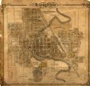
| Date: | 1920 |
|---|---|
| Description: | This map shows an arboretum and wildlife refuge in Madison, Wisconsin. There are color coded parcels "F" through "K" with acreages, as well as area around ... |

| Date: | 1927 |
|---|---|
| Description: | Map reads: "Now You Can Visualize Madison". Includes indexes, with points marked 1-98 and a key. Text and illustrations on verso include hotels and seasona... |

| Date: | 1899 |
|---|---|
| Description: | A plat map of the township of Westport. |

| Date: | 1911 |
|---|---|
| Description: | The title page of the "Atlas of Dane County, Wisconsin." |
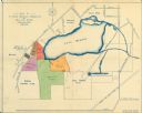
| Date: | 1906 |
|---|---|
| Description: | This map of Stoughton shows plat additions, numbered lots, some land ownership, and labeled streets. The map is color coded in blue, pink, and yellow altho... |

| Date: | 1873 |
|---|---|
| Description: | A map of the township of Primrose from the "Atlas of Dane County." |

| Date: | 1873 |
|---|---|
| Description: | A map of the township of Montrose from the "Atlas of Dane County." |

| Date: | 1861 |
|---|---|
| Description: | The township of Primrose, which is a detail from the plat map of Dane County. |

| Date: | 1861 |
|---|---|
| Description: | The township of Montrose, which is a detail from a Dane County plat map. |

| Date: | 1918 |
|---|---|
| Description: | This map shows Madison and includes an index of University of Wisconsin buildings, city buildings, and churches. Lake Mendota, Lake Monona, and Lake Wingra... |

| Date: | 1857 |
|---|---|
| Description: | This map is ink and pencil on tracing paper. The map shows plats of a western section of Madison. The lakes are labeled "Fourth Lake", "Third Lake" and "La... |

| Date: | 1851 |
|---|---|
| Description: | This map shows plats with lots and block numbers of Madison. The far left corner features "University Ground" and some streets are labeled. Lake Monona is ... |

| Date: | 1855 |
|---|---|
| Description: | This bird's-eye-view map of Madison is looking north across Lake Monona. The map features two women and two men on a lookout on top of a building in the fo... |
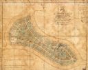
| Date: | 1865 |
|---|---|
| Description: | This map of Forest Hill Cemetery is ink and watercolor on cloth. The upper right hand margin contains an index by name and lot. The bottom left corner read... |

| Date: | 1871 |
|---|---|
| Description: | This map shows buildings, roads, the railroad, an orchard, and swamp land. Relief shown by hachures. The map includes an index of buildings in the upper ri... |
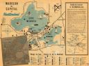
| Date: | 1950 |
|---|---|
| Description: | This map of Madison is also a brochure of activities for vacationers in the area. The map includes indexes and some points of interest are shown pictoriall... |

| Date: | 1928 |
|---|---|
| Description: | This map shows the Forest Hill Cemetery and is oriented with the north to the lower left. The map shows buildings and section numbers but does not include ... |

| Date: | 1925 |
|---|---|
| Description: | This map shows the public schools and their school districts. The bottom of the map reads:" Old buildings and sites in red. New buildings and sites in blac... |
If you didn't find the material you searched for, our Library Reference Staff can help.
Call our reference desk at 608-264-6535 or email us at: