Filter: Categories of Wisconsin Historical Images
Filter: COLLECTION_NAME of Map Collection
Filter: Categories of Wisconsin Historical Images
Filter: COLLECTION_NAME of Map Collection

| Date: | 1884 |
|---|---|
| Description: | Panorama bird's-eye view of the town of Ashland, on Lake Superior, and the Apostle Islands. |

| Date: | 1943 |
|---|---|
| Description: | This photocopy map shows inhabited farms, rivers, roads, and mills in the vicinity of Marathon City [and village of Edgar], including area between the Big ... |

| Date: | 1632 |
|---|---|
| Description: | The Wisconsin portion of Champlain's 1632 map, augmented since the previous one, for navigation according to the true Meridien, by Sieur de Champlain. The ... |

| Date: | 1918 |
|---|---|
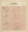
| Description: | Page from the Standard Atlas of Grant County, Wisconsin of Part of Townships 5 and 6 North, Range 5 West of the 4th P.M. |

| Date: | 03 30 1835 |
|---|---|
| Description: | Map of township # 7N, range no. 10 east, 4th meridian, including Third Lake. |

| Date: | 1892 |
|---|---|
| Description: | Bird's-eye view of the Columbian Exposition pavilions from the vantage point of Lake Michigan. Included is an inset of the Union Passenger Station (now Uni... |
| Date: | 1897 |
|---|---|
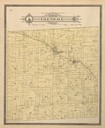
| Description: | Plat Map of Glendale Township in Monroe County. |
| Date: | 1896 |
|---|---|
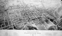
| Description: | Bird's-eye map of Platteville with twenty-two locations identified below image. Town square to left of center, behind Main Street. Area bordered by Lancast... |
| Date: | 1861 |
|---|---|
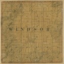
| Description: | Dane County plat map of the town of Windsor. |

| Date: | 1856 |
|---|---|
| Description: | Wisconsin map illustrating the Mineral Point Railroad and its connections. |

| Date: | 1911 |
|---|---|
| Description: | Plat Map of Blooming Grove in "Atlas of Dane County, Wisconsin." |

| Date: | 1814 |
|---|---|
| Description: | Map of the Upper Territories of the United States. |

| Date: | 1879 |
|---|---|
| Description: | Bird's-eye view drawing of various buildings on the University of Wisconsin-Madison. Buildings include: Ladies Hall, South Dormitory, University Hall, Asse... |

| Date: | 1832 |
|---|---|
| Description: | Route of Military Road from Fort Crawford to Fort Howard. Map shows beginning of route at Fort Crawford. |

| Date: | 1905 |
|---|---|
| Description: | Map of state of Idaho. Department of Interior General Land Office. |
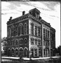
| Date: | 1889 |
|---|---|
| Description: | Madison City Hall, 2 West Mifflin Street built in 1857. |
If you didn't find the material you searched for, our Library Reference Staff can help.
Call our reference desk at 608-264-6535 or email us at: