Filter: Categories of Wisconsin Historical Images
Filter: COLLECTION_NAME of Map Collection
Filter: Categories of Wisconsin Historical Images
Filter: COLLECTION_NAME of Map Collection

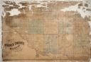
| Date: | 1915 |
|---|---|
| Description: | Plat map of Polk township in Washington County. |
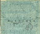
| Date: | 1859 |
|---|---|
| Description: | Detail of section 5 of the Washington County map showing only Hartford. |
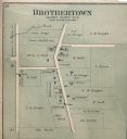
| Date: | 1893 |
|---|---|
| Description: | Plat map of Brothertown in Calumet County. |
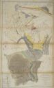
| Date: | 1851 |
|---|---|
| Description: | Owen Geological Map of Wisconsin. |
| Date: | |
|---|---|
| Description: | Geological Map of the lead regions in Wisconsin, Illinois and Iowa. |
| Date: | 04 1945 |
|---|---|
| Description: | Graphite pencil and colored pencil drawing on drafting vellum of design for Glenwood Children's Park designed by Jens Jensen. Original drawing 33 x 29 inch... |

| Date: | 04 1945 |
|---|---|
| Description: | Planting plan for Glenwood Children's Park, designed by Jens Jensen. Graphite pencil and colored pencil on tissue (overlays pencil plan) Original drawing... |

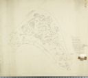
| Date: | 04 1945 |
|---|---|
| Description: | Topographic map of Park Lands in Glenwood Plat, Land for Glenwood Children's Park. Design by Jens Jensen. Oringinal drawing 35 x 34 inches. |

| Date: | 06 29 1941 |
|---|---|
| Description: | A map showing the national roots of the people of Wisconsin, based on the ethnic stock research by University of Wisconsin-Madison sociologist Prof. George... |
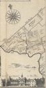
| Date: | |
|---|---|
| Description: | A detail of Philadelphia, including Mills Creek, Alms House and land ownership designations. |
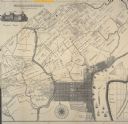
| Date: | |
|---|---|
| Description: | Detail of Philadelphia including an illustration of the Pennsylvania Hospital and the Schuykill River. |
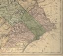
| Date: | 1775 |
|---|---|
| Description: | Detail of Pennsylvania map showing Chester, Philadelphia, and Bucks counties. |

| Date: | 1910 |
|---|---|
| Description: | Left half of a plat map of Hustisford in Dodge County. |

| Date: | 1910 |
|---|---|
| Description: | The right half of a plat map of Hustisford in Dodge County. |
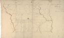
| Date: | 1869 |
|---|---|
| Description: | Hand-drawn map of York County, South Carolina. |

| Date: | 1873 |
|---|---|
| Description: | Color outline map of Dane County, Wisconsin. |

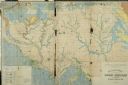
| Date: | 1820 |
|---|---|
| Description: | Map of the Northwestern Territories of the United State showing the track pursued by the Expedition in 1820. |
If you didn't find the material you searched for, our Library Reference Staff can help.
Call our reference desk at 608-264-6535 or email us at: