 Filter: Categories of Wisconsin Historical Images
Filter: COLLECTION_NAME of Place File*
Filter: Community of Madison
Filter: Type of Photograph
Filter: Categories of Wisconsin Historical Images
Filter: COLLECTION_NAME of Place File*
Filter: Community of Madison
Filter: Type of Photograph
| Date: | 1945 |
|---|---|
| Description: | Aerial view of Madison over the University Avenue-Randall Stadium area, looking toward the Congregationalist Church and the U.S. Forest Products Laboratory... |

| Date: | 1956 |
|---|---|
| Description: | Aerial view looking northeast from a point over the east end of Middleton, showing the west end of Lake Mendota (right mid-ground). Fox Bluff juts into the... |

| Date: | 1955 |
|---|---|
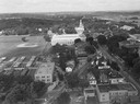
| Description: | An air view of Madison's downtown area with the Wisconsin State Capitol and new State Office Buildings. |

| Date: | 1950 |
|---|---|
| Description: | Aerial view of the Madison isthmus looking north. Caption reads: "Madison Wisconsin — Between Lake Mendota and Lake Monona". |

| Date: | 1956 |
|---|---|
| Description: | Aerial view, looking eastward from a point several miles outside the southwestern limits of Madison in the direction of Verona. Crossing the image diagonal... |

| Date: | 1956 |
|---|---|
| Description: | Aerial view looking east along Madison's Lake Mendota shoreline. The large building under construction at center is Carroll Hall, a University of Wisconsin... |

| Date: | 1956 |
|---|---|
| Description: | Aerial view over the eastern end of Lake Mendota, looking northeast. Maple Bluff is in the foreground and Truax Field is in the background. |

| Date: | 1956 |
|---|---|
| Description: | Aerial view looking south from a point over the Maple Bluff country club golf course (foreground). A new housing development in the mid-ground and Maple Bl... |

| Date: | 1924 |
|---|---|
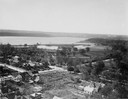
| Description: | Aerial view of Madison's Willow Beach towards the University of Wisconsin-Madison campus, downtown Madison, and Lake Monona. |
| Date: | 1924 |
|---|---|
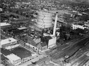
| Description: | Aerial view of a Madison Gas and Electric steam plant. |

| Date: | 1930 |
|---|---|
| Description: | Aerial view above Shorewood Hills near Madison, looking northeast. |
| Date: | 1924 |
|---|---|
| Description: | Aerial view looking southwest over Madison's Vilas Park. |

| Date: | 1919 |
|---|---|
| Description: | Aerial view from King Street looking southwest to the University of Wisconsin campus. |

| Date: | 1919 |
|---|---|
| Description: | Aerial view with the Wisconsin State Capitol in the foreground, and the tip of Monona Bay and Lake Wingra to the left, with horizon stretching into the dis... |

| Date: | 1910 |
|---|---|
| Description: | View from water of the Angle Worm Station at the foot of Carroll Street on Lake Monona. |

| Date: | 1955 |
|---|---|
| Description: | Aerial view of Atwood Avenue, looking west towards Winnebago Street and "Schenk's Corners." |

| Date: | 04 23 1926 |
|---|---|
| Description: | Madison's Automotive Electric Service Company at 122-124 West Main Street. The Loraine Hotel can be seen in the left background. |

| Date: | 1907 |
|---|---|
| Description: | The Avenue Hotel, owned and managed by George P. Gifford. Caption reads: "The Avenue Hotel, Geo. P. Gifford, Madison, Wisconsin." |

| Date: | 09 28 1940 |
|---|---|
| Description: | Badger Food Mart, Inc. at the intersection of North Henry and West Johnson Streets. |
If you didn't find the material you searched for, our Library Reference Staff can help.
Call our reference desk at 608-264-6535 or email us at:
