 Filter: Categories of Wisconsin Historical Images
Filter: COLLECTION_NAME of Place File*
Filter: Community of Madison
Filter: Creator Name of Newhouse, John
Filter: Categories of Wisconsin Historical Images
Filter: COLLECTION_NAME of Place File*
Filter: Community of Madison
Filter: Creator Name of Newhouse, John
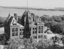
| Date: | 1958 |
|---|---|
| Description: | Elevated view of the Dane County Courthouse as it is being razed. Much of it is still intact in this image. Lake Monona and Monona Bay are in the distance. |
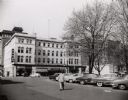
| Date: | 1954 |
|---|---|
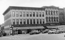
| Description: | View of the corner of Carroll and West Main Streets downtown. The Park Hotel occupies the large building. The Prescription Pharmacy, the Park Hotel Barber ... |
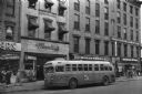
| Date: | 1955 |
|---|---|
| Description: | Bus traveling down Mifflin Street on Capitol Square. Moseleys, Woldenbergs and Walgreen's Drugs are on the right. |
| Date: | 1957 |
|---|---|
| Description: | Aerial view of the construction of Chadbourne Hall, lower Bascom Hill on the University of Wisconsin campus. |

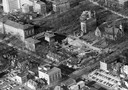
| Date: | 1956 |
|---|---|
| Description: | Aerial view of lower University of Wisconsin-Madison campus with demolition of buildings on both sides of the Armory-Gymnasium to make space for future pla... |

| Date: | 1956 |
|---|---|
| Description: | Aerial view of upper campus of the University of Wisconsin-Madison with Lake Mendota. |
| Date: | 1958 |
|---|---|
| Description: | Aerial view of upper campus on the University of Wisconsin-Madison. Typewritten labels mark the location of Elizabeth Waters Hall, New Commerce Building, L... |
| Date: | 1958 |
|---|---|
| Description: | Aerial view of the construction of the lakeshore dormitories, the recreation facilities and Lake Mendota on the University of Wisconsin Madison campus. |
| Date: | 1954 |
|---|---|
| Description: | S.S. Kresge storefront and Miller's clothing store on Main Street. |

| Date: | 1956 |
|---|---|
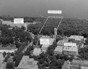
| Description: | Aerial view of the new Madison television facility, WISC-TV (Channel 3), showing the transmitting tower in construction. The location is to the southwest,... |

| Date: | 01 1946 |
|---|---|
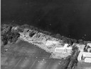
| Description: | Aerial view of the Lake Mendota shoreline during the construction of the Edgewater Hotel. It is a view looking west over the junction of Langdon Street an... |
| Date: | 1954 |
|---|---|
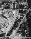
| Description: | An air view of Madison including the Veterans Hospital, Forest Products Laboratory and University Avenue from Farley (lower edge), to Allen Streets. |

| Date: | 1956 |
|---|---|
| Description: | Aerial view looking northeast from a point over the east end of Middleton, showing the west end of Lake Mendota (right mid-ground). Fox Bluff juts into the... |

| Date: | 1956 |
|---|---|
| Description: | Aerial view, looking eastward from a point several miles outside the southwestern limits of Madison in the direction of Verona. Crossing the image diagonal... |

| Date: | 1956 |
|---|---|
| Description: | Aerial view looking east along Madison's Lake Mendota shoreline. The large building under construction at center is Carroll Hall, a University of Wisconsin... |

| Date: | 1956 |
|---|---|
| Description: | Aerial view over the eastern end of Lake Mendota, looking northeast. Maple Bluff is in the foreground and Truax Field is in the background. |

| Date: | 1956 |
|---|---|
| Description: | Aerial view looking south from a point over the Maple Bluff country club golf course (foreground). A new housing development in the mid-ground and Maple Bl... |

| Date: | 1955 |
|---|---|
| Description: | Aerial view of Atwood Avenue, looking west towards Winnebago Street and "Schenk's Corners." |

| Date: | 1955 |
|---|---|
| Description: | Exterior view of Central High School with cars parked in front. |
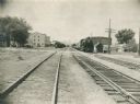
| Date: | 1955 |
|---|---|
| Description: | Chicago and North Western Railroad (CN&W) tracks between Brearly and Ingersoll Streets. |
If you didn't find the material you searched for, our Library Reference Staff can help.
Call our reference desk at 608-264-6535 or email us at: