 Filter: Categories of Wisconsin Historical Images
Filter: COLLECTION_NAME of Place File*
Filter: Subject of landforms
Filter: Categories of Wisconsin Historical Images
Filter: COLLECTION_NAME of Place File*
Filter: Subject of landforms

| Date: | 1952 |
|---|---|
| Description: | Aerial view of a North Central Airlines DC-3 airplane flying over the Madison isthmus. Clearly visible are the Wisconsin State Capitol, the 1 West Wilson S... |

| Date: | 1940 |
|---|---|
| Description: | Aerial view looking east over the center of the city and the University of Wisconsin-Madison campus. |

| Date: | 02 26 1887 |
|---|---|
| Description: | Bird's-eye map of Ashland, and the Apostle Islands in Lake Superior. Caption reads: "Ashland and the Apostle Islands." |
| Date: | 1898 |
|---|---|
| Description: | Elevated view of Observatory Hill, Observatory Hall, the Agriculture Campus and Lake Mendota on the University of Wisconsin-Madison Campus. |
| Date: | 1900 |
|---|---|
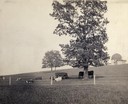
| Description: | Fenced-in, the cattle find a grassy pasture of Observatory Hill below Washburn Observatory on the University of Wisconsin-Madison campus. |
| Date: | 1899 |
|---|---|
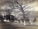
| Description: | View of home atop of Observatory Hill on the University of Wisconsin-Madison campus. |

| Date: | 1945 |
|---|---|
| Description: | View of the lower campus of the University of Wisconsin-Madison includes Bascom Hill, Wisconsin Historical Society, Memorial Union and the Armory (Red Gym ... |

| Date: | 1923 |
|---|---|
| Description: | Aerial view of the Wisconsin Historical Society, Science Hall, and Bascom Hall on Bascom Hill on the University of Wisconsin-Madison campus. Lake Mendota i... |
| Date: | 1963 |
|---|---|
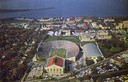
| Description: | Aerial view of Camp Randall during a football game on the University of Wisconsin-Madison campus with Picnic Point in the background. |
| Date: | 1900 |
|---|---|
| Description: | Elevated view of Observatory Hill on the University of Wisconsin Madison campus of the United States National, Wisconsin State Farm Experiment Station, Pro... |

| Date: | 1875 |
|---|---|
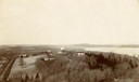
| Description: | Aerial view of Alma along Mississippi River, with bluffs along the horizon. |
| Date: | 1905 |
|---|---|
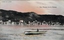
| Description: | View of Alma across the Mississippi River, with a man in a rowboat in the foreground. Caption reads: "Alma, Wisconsin, from the Mississippi." |

| Date: | 1955 |
|---|---|
| Description: | Artist's conception of ancient village of Aztalan, fortified with high walls surrounding it. |
| Date: | |
|---|---|
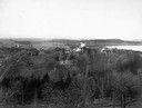
| Description: | Cassville from the bluffs. Bluffs are in the right side of the image, and the view overlooks the town. The church is the dominant structure, and the river ... |

| Date: | |
|---|---|
| Description: | Elevated view from bluff of a house in Cassville surrounded by bluffs, trees and farmland. Railroad tracks run between the crops and the trees, and the Mis... |

| Date: | 1955 |
|---|---|
| Description: | Aerial view of Cross Plains, with countryside surrounding and hills on the horizon. |

| Date: | 1902 |
|---|---|
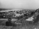
| Description: | River with distant hills behind a town. An island is in the foreground. |
| Date: | |
|---|---|
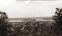
| Description: | Elevated view of the residential section of Eau Claire from Mount Tom. |

| Date: | 1870 |
|---|---|
| Description: | Elevated view of the town, looking northwest. The Chippewa River is in the foreground, with a lot of buildings, an intersection, and distant hills. One bui... |
If you didn't find the material you searched for, our Library Reference Staff can help.
Call our reference desk at 608-264-6535 or email us at:
