Filter: Categories of Wisconsin Historical Images
Filter: COLLECTION_NAME of Place File*
Filter: Categories of Wisconsin Historical Images
Filter: COLLECTION_NAME of Place File*
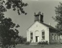
| Date: | 1941 |
|---|---|
| Description: | View of the Baptist church prior to restoration by the Lake Mills-Aztalan Historical Society. |
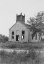
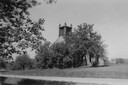
| Date: | 1941 |
|---|---|
| Description: | View of the Aztalan Baptist Church prior to restoration by the Lake Mills-Aztalan Historical Society. |
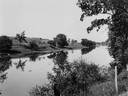
| Date: | 1910 |
|---|---|
| Description: | View of the Crawfish River in the vicinity of Aztalan. |
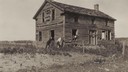
| Date: | 1920 |
|---|---|
| Description: | View of an old home or inn. Two people are looking out of an open window, and two men are standing outside leaning against the building. |
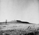
| Date: | |
|---|---|
| Description: | View of the southwest pyramidal mound in Aztalan State Park as it appeared after restoration. A person is standing on top of the mound. |
| Date: | |
|---|---|
| Description: | Elevated view of Indian village, along a river, (in a painted reconstruction) during an Indian ceremony. |
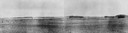
| Date: | |
|---|---|
| Description: | View from shoreline across Crawfish River, with foliage and a barbed wire fence in the foreground. |

| Date: | 1955 |
|---|---|
| Description: | Artist's conception of ancient village of Aztalan, fortified with high walls surrounding it. |
| Date: | |
|---|---|
| Description: | Distant view of Waterbury mansion, with field, road and fencing in the foreground. |
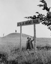
| Date: | |
|---|---|
| Description: | Little girl under the "Aztalan Mound Park" sign, in a field. Another person stands in the background on one of the mounds. |
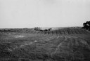
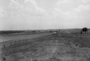
| Date: | 1945 |
|---|---|
| Description: | Field with contours, and two mounds. |
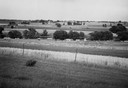
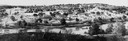
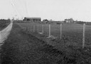
| Date: | 1945 |
|---|---|
| Description: | Field prior to the park's reconstruction, with a fence in the foreground. A river is at the bottom of the hill. |
| Date: | |
|---|---|
| Description: | View of Aztalan State Park site when it was called Aztalan Mound Park. |
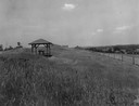
| Date: | |
|---|---|
| Description: | Pavilion in the park is on left, with a fence along the right. |

| Date: | 08 14 1932 |
|---|---|
| Description: | The watershed sign unveiled. The marker is 39 miles south of Ashland adjacent to Highway 13, 2 miles north of Gordon Lake. |

| Date: | 08 14 1932 |
|---|---|
| Description: | Watershed sign unveiled with ceremony participants. The marker is 39 miles south of Ashland adjacent to Highway 13, 2 miles north of Gordon Lake. |
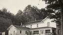
| Date: | 1925 |
|---|---|
| Description: | Home of ex-Governor Emanuel Lorenz Philipp, in Badger?. |
If you didn't find the material you searched for, our Library Reference Staff can help.
Call our reference desk at 608-264-6535 or email us at: