Filter: Categories of Wisconsin Historical Images
Filter: COLLECTION_NAME of Place File**
Filter: County of Dane
Filter: Subject of fields (agriculture)
Filter: Categories of Wisconsin Historical Images
Filter: COLLECTION_NAME of Place File**
Filter: County of Dane
Filter: Subject of fields (agriculture)

| Date: | 1862 |
|---|---|
| Description: | Camp Randall looking southwest. In April 1861, Governor Alexander Randall asked that the State Agricultural Society fairgrounds be converted into a militar... |

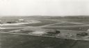
| Date: | 1908 |
|---|---|
| Description: | Aerial view of Camp Randall Field on the University of Wisconsin-Madison campus. University Heights is in the background. |
| Date: | 1903 |
|---|---|
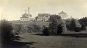
| Description: | View towards the College of Agriculture on the University of Wisconsin campus, with Bascom Hall in the distance on a hill. |
| Date: | 1880 |
|---|---|
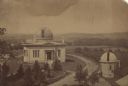
| Description: | Elevated view of the University of Wisconsin-Madison Washburn Observatory. Hill, trees and fields are in the background. A man is standing near a small obs... |

| Date: | 1956 |
|---|---|
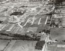
| Description: | Aerial view of the new Madison television facility, WISC-TV (Channel 3), showing the transmitting tower in construction. The location is to the southwest,... |

| Date: | 1956 |
|---|---|
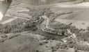
| Description: | Aerial view, looking eastward from a point several miles outside the southwestern limits of Madison in the direction of Verona. Crossing the image diagonal... |

| Date: | 1930 |
|---|---|
| Description: | Aerial view above Shorewood Hills near Madison, looking northeast. |
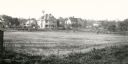
| Date: | 1909 |
|---|---|
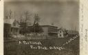
| Description: | A view from a field towards a row of residences and commercial buildings. Caption reads: "A Portion of Pine Bluff, Village." |
| Date: | 1955 |
|---|---|
| Description: | An aerial view at Truax Field showing the Municipal Airport Administration Building. |
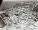
| Date: | 1902 |
|---|---|
| Description: | View across field towards two residences of University of Wisconsin Professors. At 1532 University Avenue is the Harry L. Russell home and at 1540 Universi... |
| Date: | 1913 |
|---|---|
| Description: | View looking southwest at the University Heights neighborhood from near the corner of University Avenue and Breese Terrace. In the foreground is the Univer... |
| Date: | 09 1958 |
|---|---|
| Description: | Aerial view of University Farms neighborhood near Lake Mendota. |
| Date: | 09 1958 |
|---|---|
| Description: | University Hill Farms from an aerial perspective. |

| Date: | 1900 |
|---|---|
| Description: | Elevated view looking towards Monona Bay, possibly from atop the University of Wisconsin Power Plant smokestack. |

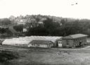
| Date: | 1910 |
|---|---|
| Description: | Aerial view looking toward Lake Wingra. In the foreground is the Yawkey-Crowley Lumber Yard. The company built it's warehouse at 1542 Monroe Street between... |
| Date: | 06 1955 |
|---|---|
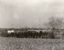
| Description: | View towards the Wisconsin State Capitol from the outlying area around Madison. Just beyond the cornfield in the foreground are buildings, one with a sign ... |
If you didn't find the material you searched for, our Library Reference Staff can help.
Call our reference desk at 608-264-6535 or email us at: