Filter: Categories of Wisconsin Historical Images
Filter: COLLECTION_NAME of Place File****
Filter: Type of Photograph
Filter: County of Ozaukee
Filter: Categories of Wisconsin Historical Images
Filter: COLLECTION_NAME of Place File****
Filter: Type of Photograph
Filter: County of Ozaukee
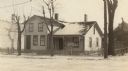
| Date: | 1915 |
|---|---|
| Description: | "Gen." Wooster Harrison house. Sign in front reads, "Lincolns Abode/West Wing/1835". |
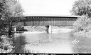
| Date: | 1940 |
|---|---|
| Description: | Exterior view of the last covered bridge in Wisconsin. Caption reads: "Covered Bridge Near Cedarburg, Wis." |
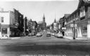
| Date: | 1950 |
|---|---|
| Description: | View of the central business area on Franklin Street. On the right corner is the "Fish Shanty" Restaurant and on the left is the Rexall Drugstore. |
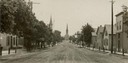
| Date: | 1907 |
|---|---|
| Description: | View down center of unpaved street in Cedarburg, with a large church at the far end. |
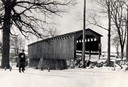
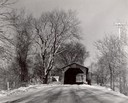
| Date: | 1934 |
|---|---|
| Description: | Southwest view of a covered bridge over Cedar Creek, with a man walking in the snow nearby. |
| Date: | 1966 |
|---|---|
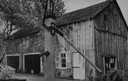
| Description: | Button factory at the Wetzel residence. At one time, bone buttons were manufactured in this building. A cat and a hand pump are in the foreground. |
| Date: | 1933 |
|---|---|
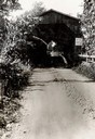
| Description: | View down dirt road towards the covered bridge over Cedar Creek, south approach. |
| Date: | 1940 |
|---|---|
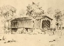
| Description: | Drawing of a covered bridge in Cedarburg. |
| Date: | 1940 |
|---|---|
| Description: | Last covered bridge to remain standing in Wisconsin. In the distance an automobile is parked on the side of the road in the shade of a tree. Caption along ... |
| Date: | 1957 |
|---|---|
| Description: | Covered bridge over Cedar Creek in Ozaukee County on highway, about one mile north of Cedarburg. The last remaining covered bridge in Wisconsin. Snow is on... |
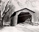
| Date: | 1957 |
|---|---|
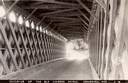
| Description: | View through the covered bridge over Cedar Creek in Ozaukee County on highway, about one mile north of Cedarburg. The last remaining covered bridge in Wisc... |
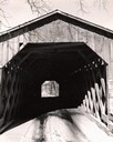
| Date: | 1957 |
|---|---|
| Description: | Covered bridge over Cedar Creek in Ozaukee County on highway, about one mile north of Cedarburg. The last remaining covered bridge in Wisconsin. Snow is on... |

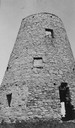
| Date: | 1872 |
|---|---|
| Description: | Wind powered stone grist mill. Two men stand on a wood balcony near the open doorway of the windmill. |
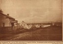
| Date: | 1850 |
|---|---|
| Description: | Main Street in Cedarburg. Includes text which reads: "Cedarburg, Wis., in the year 1850, showing Main Street as it appeared at that time. The photograph wa... |
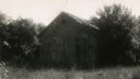
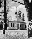
| Date: | 06 14 1946 |
|---|---|
| Description: | View of the school surrounded by trees, out in an overgrown field during a warm season. Stony Hill School house, where the first Flag Day was celebrated on... |
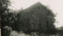
| Date: | 06 14 1946 |
|---|---|
| Description: | Stony Hill School house, where the first Flag Day was celebrated on June 14, 1885. |
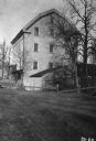
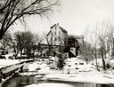
| Date: | 1934 |
|---|---|
| Description: | Exterior of Concordia Mills, once a grain/grist mill. |
If you didn't find the material you searched for, our Library Reference Staff can help.
Call our reference desk at 608-264-6535 or email us at: