 Filter: Categories of Wisconsin Historical Images
Filter: COLLECTION_NAME of Place File****
Filter: County of Eau Claire
Filter: Type of Photograph
Filter: Categories of Wisconsin Historical Images
Filter: COLLECTION_NAME of Place File****
Filter: County of Eau Claire
Filter: Type of Photograph
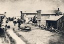
| Date: | 1860 |
|---|---|
| Description: | Elevated view of Barstow Street looking north. View from the corner of Main Street, where the Eau Claire Book and Stationary Company later stood, looking n... |
| Date: | |
|---|---|
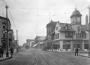
| Description: | Caption reads: "Main St. Looking West. Augusta, Wis." Livesey Drugs is on the left side of the street. |
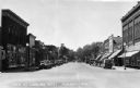
| Date: | 1910 |
|---|---|
| Description: | View looking south on Barstow Street. |
| Date: | |
|---|---|
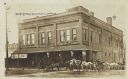
| Description: | View from street of a group of people, including a number of horse-drawn vehicles, standing outside of the main entrance to the Cox Brothers company on Cox... |
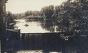
| Date: | |
|---|---|
| Description: | Front view of dam and waterfall at Dells Pond. There is a building on the left of the dam. People are fishing from a boat on the pond. |
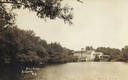
| Date: | |
|---|---|
| Description: | Caption reads: "Mill Pond, Augusta, Wis." View across water towards a large building on the far shoreline. Tree-lined shore on the left. |

| Date: | 1930 |
|---|---|
| Description: | Aerial view of Carson Park, Half Moon Lake and part of the West Side in the foreground. The municipal bath house is on the lake shore in the foreground. A ... |

| Date: | 1930 |
|---|---|
| Description: | Aerial view of city, with Eau Claire River is in the foreground with Milwaukee railroad bridge at left. Gillette Rubber Co. plant is in center with Omaha r... |

| Date: | 1931 |
|---|---|
| Description: | Aerial view looking north, with a small portion of the West Side (left), nearly all of the North Side and part of the business district of the East Side. A... |
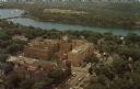
| Date: | |
|---|---|
| Description: | Aerial view of the hospital along the banks of a river, with a bridge on the far left. Beyond the river is a baseball park. On the back of the card is writ... |

| Date: | |
|---|---|
| Description: | Aerial view of the high school, 2100 Fenwick Avenue, and the surrounding roads. |
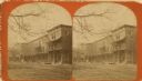
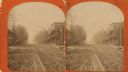
| Date: | 1884 |
|---|---|
| Description: | Stereograph of three-story brick building on a dirt road. |
| Date: | 1884 |
|---|---|
| Description: | Stereograph view with the Meggett building on the right hand side, and another building along the left hand side. A church's steeple is visible behind the ... |
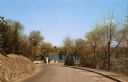
| Date: | |
|---|---|
| Description: | View down a road in the park, leading to a river and a bridge. |
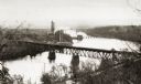
| Date: | |
|---|---|
| Description: | Elevated view of the river with multiple bridges across it, including at least two railroad bridges. There is a factory on the left bank with smokestacks, ... |
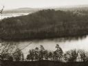
| Date: | |
|---|---|
| Description: | Elevated view of the "mount" and the wide river before it and behind it. Houses and smokestacks can be seen in the far distance. |
| Date: | |
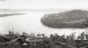
|---|---|
| Description: | Elevated view of a bow in the river, and a homestead on the shore, with a two-story house and a barn. Two wagons are close to the barn in the lower left co... |
| Date: | |
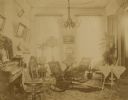
|---|---|
| Description: | Interior view of a parlor. A chandelier is hanging from the ceiling, and multiple photographs and portraits are displayed on the walls. There is a piano al... |
| Date: | |
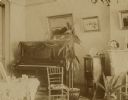
|---|---|
| Description: | View of the piano in the parlor, with two potted plants on the floor, a chair, and a nightstand. Three framed pictures are hanging on the wall, and a statu... |

| Date: | |
|---|---|
| Description: | View from street towards the residence during the spring or summer. Home of William K. Coffin family. |
If you didn't find the material you searched for, our Library Reference Staff can help.
Call our reference desk at 608-264-6535 or email us at: