Filter: Categories of Wisconsin Historical Images
Filter: COLLECTION_NAME of Place File****
Filter: County of Waupaca
Filter: Categories of Wisconsin Historical Images
Filter: COLLECTION_NAME of Place File****
Filter: County of Waupaca
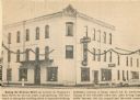
| Date: | 1964 |
|---|---|
| Description: | View of the Delavan Hotel with accompanying caption. |
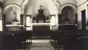
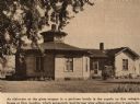
| Date: | |
|---|---|
| Description: | Interior view of the Loyola Villa Chapel, looking towards the altar. |
| Date: | 1870 |
|---|---|
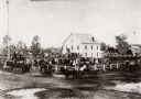
| Description: | View of an unidentified ceremony taking place at the public square on the steps of the original Waupaca County Courthouse. |
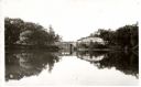
| Date: | 1940 |
|---|---|
| Description: | View of Taylor Lake and the entrance to Chain O' Lakes. |

| Date: | 1910 |
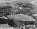
|---|---|
| Description: | Aerial view of some of the 26 lakes known collectively as the Chain O' Lakes. Caption reads: "Aeroplane View of Chain O'Lakes, Waupaca, Wis." |
| Date: | 1905 |
|---|---|
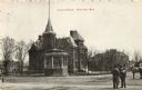
| Description: | Exterior view of the Waupaca courthouse. Caption reads: "Court House, Waupaca, Wis." |
| Date: | 1895 |
|---|---|
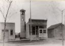
| Description: | Village Hall in Marion with a bell tower on the left side of the building. Caption reads: "Marion, Wis." |
| Date: | 1955 |
|---|---|
| Description: | Exterior view of a Swiss chapel built by the Count and Countess Erick Von Bretzel in 1893. |
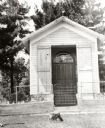
| Date: | 1965 |
|---|---|
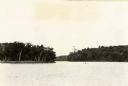
| Description: | Aerial view looking west-northwest over Silver Lake. |
| Date: | 1940 |
|---|---|
| Description: | Exterior view of the Octagon House. |

| Date: | 1930 |
|---|---|
| Description: | Exterior view across street towards the library and museum. Caption reads: "Library and Museum, New London, Wis." |

| Date: | 1905 |
|---|---|
| Description: | View includes a bank and other buildings. People are on the sidewalks. |
| Date: | 1965 |
|---|---|
| Description: | Aerial view, looking east. Highway 49 is at center. |

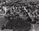
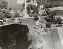
| Date: | 1965 |
|---|---|
| Description: | Elevated view of roads, railroad tracks, building, farm fields, and a body of water. |
If you didn't find the material you searched for, our Library Reference Staff can help.
Call our reference desk at 608-264-6535 or email us at: