 Filter: Categories of Wisconsin Historical Images
Filter: Creator Name of Cram, Thomas Jefferson
Filter: Subject of bays
Filter: Categories of Wisconsin Historical Images
Filter: Creator Name of Cram, Thomas Jefferson
Filter: Subject of bays
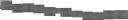
| Date: | 1900 |
|---|---|
| Description: | This map shows the distances and land use and type along the road from Green Bay to Racine. A few places are labeled, including Devil River, Sheboygan Rive... |
If you didn't find the material you searched for, our Library Reference Staff can help.
Call our reference desk at 608-264-6535 or email us at: