 Filter: Categories of Wisconsin Historical Images
Filter: Creator Name of Kenyon Company
Filter: Year of 1900-1999
Filter: Categories of Wisconsin Historical Images
Filter: Creator Name of Kenyon Company
Filter: Year of 1900-1999

| Date: | 1914 |
|---|---|
| Description: | Atlas and farm directory of the Washara County containing Plats of all the Townships with Owners' Names; also Maps of the State, United States and World; a... |
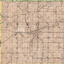
| Date: | 1914 |
|---|---|
| Description: | The Verona township, a detail of the Dane County, Wisconsin map of land ownership. |

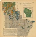
| Date: | 1914 |
|---|---|
| Description: | A hand-colored map of Wisconsin showing the locations of cities and towns, counties, railway lines, the steamship lines in Lake Superior and lake Michigan.... |
| Date: | 1920 |
|---|---|
| Description: | This map shows the township and range system, sections, cities and villages, railroads, roads, and streams and lakes in Oconto County, Wisconsin. Color co... |

| Date: | 1913 |
|---|---|
| Description: | This 1913 map of Pepin County, Wisconsin, shows the township and range grid, towns, villages, rural routes, railroads, roads, schools, churches, cemeteries... |

| Date: | 1914 |
|---|---|
| Description: | This map of Price County, Wisconsin, from the early 20th century shows land for sale by the Homemaker Land Company of Milwaukee. The township and range sys... |

| Date: | 1912 |
|---|---|
| Description: | This early 20th century map of Barron County, Wisconsin, shows the township and range grid, towns, sections, cities and villages, railroads, roads, houses,... |

| Date: | 1900 |
|---|---|
| Description: | This early 20th century map of Chippewa County, Wisconsin, shows the township and range grid, towns, sections, cities and villages, roads, railroads, schoo... |
| Date: | 1914 |
|---|---|
| Description: | This early-20th century map of Clark County, Wisconsin, shows the township and range grid, towns, sections, cities and villages, property owners and acreag... |

| Date: | 1929 |
|---|---|
| Description: | Map shows townships and sections, landownership and acreages, roads, schools, school districts, churches, and cemeteries. Includes index of acreage tracts. |

| Date: | 1915 |
|---|---|
| Description: | This map includes automobile routes through the state as well as routes in parts of Iowa, Michigan and Minnesota. Cities, counties, Lake Michigan, Lake Sup... |
If you didn't find the material you searched for, our Library Reference Staff can help.
Call our reference desk at 608-264-6535 or email us at: