 Filter: Categories of Wisconsin Historical Images
Filter: Creator Name of Railroad Commission of Wisconsin.
Filter: Categories of Wisconsin Historical Images
Filter: Creator Name of Railroad Commission of Wisconsin.

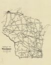
| Date: | 1880 |
|---|---|
| Description: | This map shows railroads by operator and projected railroads. Portions of Lake Michigan, Lake Superior, Illinois, Iowa, Michigan and Minnesota are labeled. |

| Date: | 1904 |
|---|---|
| Description: | This map shows lakes, railroads, and rivers. Also includes an explanation of railroad lines and mileage and a table showing miles from cities to Milwaukee.... |

| Date: | 1912 |
|---|---|
| Description: | This map shows counties, roads, Lake Superior, Lake Michigan, and a portion of Illinois, Iowa, Minnesota, and Michigan. Also included is a list of railroad... |

| Date: | 1908 |
|---|---|
| Description: | This map shows counties, roads, Lake Superior, Lake Michigan, and portions of surrounding states. Also included is a list of railroads showing miles and g... |

| Date: | 1910 |
|---|---|
| Description: | This map shows counties, roads, Lake Superior, Lake Michigan, and portions of surrounding states. Also included is a list of railroads showing miles and gr... |

| Date: | 1914 |
|---|---|
| Description: | This map shows counties, roads, Lake Superior, Lake Michigan, and portions of surrounding states. Also included is a list of railroads showing miles and gr... |

| Date: | 1923 |
|---|---|
| Description: | This map shows counties, roads, Lake Superior, Lake Michigan, and portions of surrounding states. Included is an index to cities, villages and other places... |

| Date: | 1921 |
|---|---|
| Description: | This map shows counties, roads, Lake Superior, Lake Michigan, and portions of surrounding states. Included is an index to cities, villages and other places... |

| Date: | 1928 |
|---|---|
| Description: | This map shows rates on cattle, hogs and sheep, and mileage from Wisconsin points to Chicago, Illinois. The top margin reads: "Before the Interstate Commer... |
| Date: | 1929 |
|---|---|
| Description: | This map shows railroad routes throughout the state. |

| Date: | 1910 |
|---|---|
| Description: | This map shows counties, roads, Lake Superior, Lake Michigan, and portions of surrounding states. Included is a table of interstate and intrastate railroa... |

| Date: | 1902 |
|---|---|
| Description: | This map shows lakes, railroads, and rivers. Also includes an explanation of railroad lines and mileage, information on state institutions, normal schools,... |

| Date: | 1900 |
|---|---|
| Description: | This map shows railroad routes in red, blue, orange, brown, pink, green, and dotted, as well as lakes, rivers, and communities. The map includes a legend i... |

| Date: | 1927 |
|---|---|
| Description: | These maps are compiled from existing maps created by the Joint Engineering Department, the Wisconsin Railroad, and the Tax Commissions. The maps include n... |
If you didn't find the material you searched for, our Library Reference Staff can help.
Call our reference desk at 608-264-6535 or email us at: