Filter: Categories of Wisconsin Historical Images
Filter: Creator Name of Ross, Hamilton Nelson
Filter: Subject of cities and towns
Filter: Categories of Wisconsin Historical Images
Filter: Creator Name of Ross, Hamilton Nelson
Filter: Subject of cities and towns

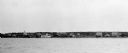
| Date: | 1910 |
|---|---|
| Description: | View of La Pointe taken from Big Bay Road on Madeline Island. |
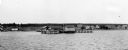
| Date: | 1912 |
|---|---|
| Description: | Elevated view of La Pointe dock taken from the water. |

| Date: | 1952 |
|---|---|
| Description: | This 1952 map of the northern parts of Bayfield and Douglas counties, Wisconsin, shows points established by E.T. Sweet in 1877, road points confirmed by S... |

| Date: | 1952 |
|---|---|
| Description: | This map of the northern parts of the Chequamegon Bay area in Bayfield and Ashland counties, Wisconsin, shows trails, roads, railroads, stations, the towns... |
If you didn't find the material you searched for, our Library Reference Staff can help.
Call our reference desk at 608-264-6535 or email us at: