Filter: Categories of Wisconsin Historical Images
Filter: Creator Name of Unknown
Filter: Reproduction Rights of For Sale
Filter: Subject of aids to navigation
Filter: Categories of Wisconsin Historical Images
Filter: Creator Name of Unknown
Filter: Reproduction Rights of For Sale
Filter: Subject of aids to navigation
| Date: | |
|---|---|
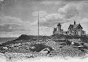
| Description: | Eastern Point Lighthouse at "Mother Ann" and residence on rocky point, Gloucester, Massachusetts. Mother Ann is a rocky cliff at the far south end of Easte... |

| Date: | 1872 |
|---|---|
| Description: | Map of the Chippewa River, from the head of navigation at the city of Chippewa Falls, covering a distance of 16 miles above : showing the established impro... |

| Date: | 1890 |
|---|---|
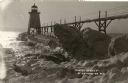
| Description: | View from the shore of Kenosha's North Pier and lighthouse. Waves are breaking on the shore of Lake Michigan. |
| Date: | |
|---|---|
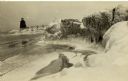
| Description: | View of ice coated pier and lighthouse along the shore of Lake Michigan. Caption reads: "Winter Scene at Port Washington, Wis." |
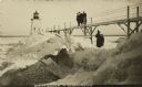
| Date: | |
|---|---|
| Description: | Postcard view along icy shoreline of the pier and lighthouse on Lake Michigan at Port Washington in winter. |
| Date: | |
|---|---|
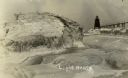
| Description: | Winter postcard view of the pier and lighthouse at Port Washington seen from the icy shore of Lake Michigan. Caption reads: "Light House." |
| Date: | |
|---|---|
| Description: | Winter view of the lighthouse at Port Washington from the icy shore of Lake Michigan. Two people can be seen standing on a pier in the distance. |
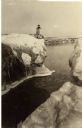
| Date: | 1910 |
|---|---|
| Description: | Postcard view of three men on an elevated walk on an icy pier near the shoreline. A women and young boy stand on the pier below the walk. There is a lighth... |
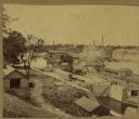
| Date: | |
|---|---|
| Description: | Elevated view of a lock at Appleton, with views of mills and other structures in the background. |
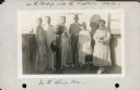
| Date: | 10 31 1930 |
|---|---|
| Description: | Alma Seipp Hay, second from right, and her husband, William Sherman Hay, third from left, join Commander C.W. Berndtson and other passengers on the bridge... |

| Date: | 1905 |
|---|---|
| Description: | This map shows railroads, towns, lights, lights to be established, fog signals, light-vessels, lighted buoys, light-house depots, and light-house reservati... |

| Date: | 1782 |
|---|---|
| Description: | Map of the West Indies and south eastern North America, remarkably detailed, showing cities, mountains, rivers, lakes, mines, plantations, forts, banks, an... |

| Date: | 1780 |
|---|---|
| Description: | Map of Connecticut, Rhode Island, and Long Island. it shows the borders, cities, roads, islands, mountains, lakes and rivers. Navigational hazards along th... |
If you didn't find the material you searched for, our Library Reference Staff can help.
Call our reference desk at 608-264-6535 or email us at: