 Filter: Categories of Wisconsin Historical Images
Filter: Community of Appleton
Filter: Subject of human settlements
Filter: Categories of Wisconsin Historical Images
Filter: Community of Appleton
Filter: Subject of human settlements

| Date: | 01 1940 |
|---|---|
| Description: | Map shows roads, railroads, the Fox River, parks, schools, and cemeteries and is indexed by street name in the margins. The bottom of the map show the Winn... |

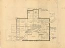
| Date: | 04 1956 |
|---|---|
| Description: | Map includes an index for building locations on the Lawrence University campus in the upper right hand corner. Map shows roads, rivers, campus buildings by... |

| Date: | 1957 |
|---|---|
| Description: | Map is indexed by street name in the margins. The map shows roads, highways, railroads, parks, city buildings, schools, cemeteries, city limits, and the Fo... |

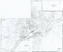
| Date: | 1968 |
|---|---|
| Description: | This map shows local streets, wards, buildings, parks, and part of the Fox River. The map is also indexed by street name. Ward borders and numbering and th... |

| Date: | 1960 |
|---|---|
| Description: | This map shows local streets, wards, public buildings, parks, and part of the Fox River. The land is shown in white and the water is shown in blue. The map... |
| Date: | 1949 |
|---|---|
| Description: | This map is ink and pencil on paper and shows land ownership by name, years of purchase, and city limits. Also included on the right and bottom margins are... |
| Date: | 1985 |
|---|---|
| Description: | This photocopied map shows the area as it appeared in 1889. The map shows buildings, lot numbers, some landownership, and the Fox River. |

| Date: | 1874 |
|---|---|
| Description: | Birds-eye view of Appleton Wisconsin. In the foreground are people fishing, strolling, and looking over the canal towards the Fox River. Streets and buildi... |
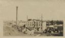
| Date: | |
|---|---|
| Description: | Elevated view from hill of the Atlas Paper Mill owned by the Kimberly Clark Paper Company. |
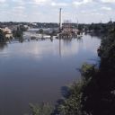
| Date: | |
|---|---|
| Description: | Elevated view over trees towards the Fox River. A dam is creating a reservoir for hydroelectric power. Former paper mills are on the left shore of the rive... |
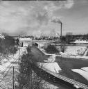
| Date: | 02 1951 |
|---|---|
| Description: | Elevated view of the Fox River Valley from Memorial Drive bridge, looking East. Snow is on the ground, ice is on the river and the smokestacks are billowin... |

| Date: | 10 1969 |
|---|---|
| Description: | A football player is leaping to avoid a tackle at Lawrence University. Two people are watching from the hillside in the background. |
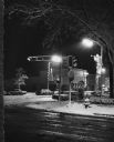
| Date: | 12 1970 |
|---|---|
| Description: | Fresh snow covers everything on a city street at Christmas time. |

| Date: | 1935 |
|---|---|
| Description: | Four uniformed police officers holding guns are posing alongside a car, with two other men. A brick building behind them has a sign on the window that read... |

| Date: | 1963 |
|---|---|
| Description: | Elevated view from East College Avenue bridge of motor boats exiting Lock #4 on the Upper Fox River. |

| Date: | 1896 |
|---|---|
| Description: | View down street towards the George Walter Brewing Company. A large group of people are posing on the street with horse-drawn carriages and horse-drawn wag... |
If you didn't find the material you searched for, our Library Reference Staff can help.
Call our reference desk at 608-264-6535 or email us at: