 Filter: Categories of Wisconsin Historical Images
Filter: Community of Ashland
Filter: Subject of water
Filter: Categories of Wisconsin Historical Images
Filter: Community of Ashland
Filter: Subject of water

| Date: | 1887 |
|---|---|
| Description: | This 1887 map of Ashland County, Wisconsin, shows the township and range system, sections, railroads, vacant Wisconsin Central Railroad land, state and "go... |

| Date: | 1896 |
|---|---|
| Description: | This 1896 map shows the township and range system, sections, cities and villages, railroads, roads, vacant land and land sold by the Wisconsin Central Rail... |

| Date: | 1896 |
|---|---|
| Description: | This 1898 map shows the township and range system, sections, cities and villages, railroads, roads, vacant land and land sold by the Wisconsin Central Rail... |

| Date: | 1908 |
|---|---|
| Description: | Title at top: "G.F. Sanborn Company Timber and Farming Lands." Map shows acreages, roads, railroads, and swamps in parts of Vilas and Oneida counties. |

| Date: | 1850 |
|---|---|
| Description: | Map is pen and pencil on paper. The map shows roads, creeks, and the Chequamegon Bay. The map is undated and prepared sometime between the establishment of... |

| Date: | 09 04 1885 |
|---|---|
| Description: | Exterior and interior bill of fare from The Chequamegon, with views on the back of rock formations, waterfalls, a spot illustration of a train going over a... |
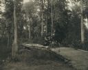
| Date: | |
|---|---|
| Description: | Dr. W.T. Rinehart, a prominent Ashland physician and surgeon, with Mrs. Rinehart and a sister, in an automobile crossing a small log bridge, probably over ... |

| Date: | 1951 |
|---|---|
| Description: | This map shows Ashland and Washburn harbors in shades of blue and yellow. Water depths shown by isolines and soundings, and relief is shown by contours. Th... |

| Date: | 1888 |
|---|---|
| Description: | This map shows wards and includes the Chequamegon Bay and Washburn. An inset map shows the Ashland region, its railroads, and a few of its iron mines. |

| Date: | 1900 |
|---|---|
| Description: | This map is shows land in white and water in blue and is indexed for parks, points of interest, schools, churches, and recreational areas. The map shows lo... |

| Date: | 1924 |
|---|---|
| Description: | This map is pen, pencil, and watercolor on paper and shows land ownership by name, local streets, railroads, and part of Chequamegon Bay. The map includes ... |

| Date: | 1900 |
|---|---|
| Description: | This map is pencil and ink on tracing cloth and shows local streets, railroads, harbor line, and part of Chequamegon Bay. |

| Date: | 06 1923 |
|---|---|
| Description: | Sanborn map of Ashland, which includes Chequamegon Bay. |
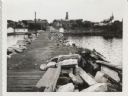
| Date: | 09 14 1962 |
|---|---|
| Description: | View from pier, lined with rocks, towards town. There are industrial buildings along the shoreline, and up a small rise is a building with a tower, and on ... |
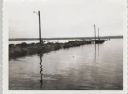
| Date: | 09 14 1962 |
|---|---|
| Description: | View across water towards jetty and dock, with three lampposts, from south east. |

| Date: | 1985 |
|---|---|
| Description: | This map shows mining, White River, Silver Creek, Bad River, Agogic Lake, Chequamegon Bay, smaller lakes, the Bad River Indian Reservation, and communities... |

| Date: | |
|---|---|
| Description: | Man sitting at the aft of a canoe in a wooded river area. There is an outboard motor leaning against a tree in the center of the image. Handwritten text ca... |
| Date: | 1935 |
|---|---|
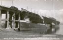
| Description: | Aerial view of crew members standing and sitting on the deck of the ore boat Captain Thomas Wilson in Ashland harbor. |
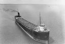
| Date: | 1935 |
|---|---|
| Description: | View from shoreline towards three ore boats at the Soo Line Railroad dock being loaded with iron ore. The first in line is the William B. Pilkey. |
If you didn't find the material you searched for, our Library Reference Staff can help.
Call our reference desk at 608-264-6535 or email us at:
