 Filter: Categories of Wisconsin Historical Images
Filter: Community of Brodhead
Filter: Subject of water
Filter: Categories of Wisconsin Historical Images
Filter: Community of Brodhead
Filter: Subject of water

| Date: | 1871 |
|---|---|
| Description: | Birds eye map of Brodhead, WI depicts street names and street locations, houses, and trees. A reference key at the bottom of the map shows the locations of... |
| Date: | |
|---|---|
| Description: | Colorized postcard view of the Decatur Dam. The shoreline and trees are visible in the background. Text at the top reads: "Decatur Dam, Brodhead, Wis." |
| Date: | 11 31 1910 |
|---|---|
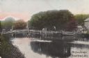
| Description: | Colorized postcard view of The Spring in Decatur Park. A man is sitting near the spring. There is a bridge on the right, and many trees. Text in red in the... |

| Date: | |
|---|---|
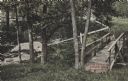
| Description: | Colorized postcard view of the Old Clarance Bridge, a covered bridge. Text in red in the upper right corner reads: "Old Clarance Bridge, Brodhead, Wis." |
| Date: | |
|---|---|
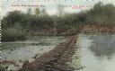
| Description: | Colorized postcard view of the Cow Bridge. A farm is on the shoreline on the right. A man is standing on the bridge. Text in the lower right corner reads: ... |
| Date: | 08 25 1903 |
|---|---|
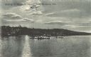
| Description: | Colorized postcard view across water towards people in boats on the lake in Decatur Park. It is evening and the moon is shining on the lake. Caption reads:... |
| Date: | 1917 |
|---|---|
| Description: | View of a fountain in an octagonal basin at the Wisconsin Veteran's Memorial Park. There is a monument of a soldier behind it. Dwellings surround the park. |
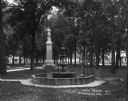
| Date: | 1924 |
|---|---|
| Description: | The Municipal Light and Power Plant and water tower seen from across a pond. |

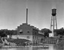
| Date: | 1856 |
|---|---|
| Description: | This map of Brohead shows land and lot ownerships by name and color, as well as roads, and railroads. |

| Date: | 1908 |
|---|---|
| Description: | A Sanborn fire map of Brodhead. Includes an inset at top right showing distances from P.O. |
If you didn't find the material you searched for, our Library Reference Staff can help.
Call our reference desk at 608-264-6535 or email us at: