 Filter: Categories of Wisconsin Historical Images
Filter: Community of Fort Atkinson
Filter: Subject of human settlements
Filter: Categories of Wisconsin Historical Images
Filter: Community of Fort Atkinson
Filter: Subject of human settlements
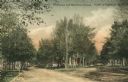
| Date: | 1910 |
|---|---|
| Description: | View of unpaved Whitewater and Merchants Avenue. Caption reads: "Whitewater and Merchants Avenue." |
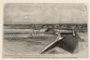
| Date: | 1876 |
|---|---|
| Description: | Elevated view of Fort Howard taken from Elmore and Kelly's Elevator with the dam and river. A tugboat is in the river above the dam. Caption reads: "View o... |

| Date: | |
|---|---|
| Description: | A three and one-half story brick structure, entrance in the middle, and a flag pole on the left. |
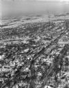
| Date: | 01 22 1949 |
|---|---|
| Description: | Aerial photograph of the city of Fort Atkinson. |

| Date: | 07 21 1962 |
|---|---|
| Description: | A parking lot underneath a newly developed block of stores. The Rock River is visible just beyond the parking lot. There is a bridge in the background. |
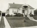
| Date: | 06 1926 |
|---|---|
| Description: | Front yard landscaping of suburban house including foundation planting, terraced lawn, and window boxes. On the left is a driveway leading to a garage. |

| Date: | |
|---|---|
| Description: | View over tree-tops toward a man rowing a boat beneath a partially covered bridge spanning the Rock River. Factories, industrial buildings, and Saint Paul'... |

| Date: | |
|---|---|
| Description: | View down Milwaukee Avenue. On the left side of the road, the Daughters of the American Revolution Monument, erected in 1907, can be seen among trees trea... |
| Date: | 1908 |
|---|---|
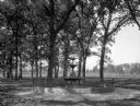
| Description: | View of Jones Fountain at Barrie Park, erected in 1905. The fountain stands among trees and a park bench, and dwellings are in the background. |

| Date: | |
|---|---|
| Description: | Exterior view across road toward the Methodist Church. Children play with a wagon on the sidewalk in front of the church. Two sets of stairs lead to a side... |

| Date: | |
|---|---|
| Description: | Exterior of Ward Public School. The sidewalk leads to an entrance where a sign reads: "Public School." |

| Date: | |
|---|---|
| Description: | View down South Main Street. Houses are on the left, and trees line the street. |
| Date: | |
|---|---|
| Description: | Letterhead of Hoard's Dairyman, "The National Dairy Farm Magazine," with a bird's eye view of the company farm buildings, and a mailbox with an upraised fl... |

| Date: | 09 1884 |
|---|---|
| Description: | Sanborn map of Fort Atkinson including Barrie, Germany, and North Water Streets. |

| Date: | 09 1884 |
|---|---|
| Description: | Sanborn map of Fort Atkinson including South Water and Milwaukee Streets. |

| Date: | 1870 |
|---|---|
| Description: | Bird’s-eye view map. "Looking north east." Indexed for points of interest. Shows homes, businesses, and the Bark and Rock River. Streets running west to ea... |

| Date: | 1920 |
|---|---|
| Description: | Shows ward boundaries, corporation limits, plat of town, land ownership by name, local streets, parks, railroads, and parts of Rock River. Wards appear in ... |

| Date: | 1947 |
|---|---|
| Description: | Lower left hand corner features a legend. "Drawn 1938, revised 1947." Shows water mains, hydrants, corporation limits, city ward divisions, fire proof buil... |

| Date: | 1976 |
|---|---|
| Description: | Includes index of streets and of local businesses. Shows location of Citizens State Bank, roads, highways, railroads, parks, cemeteries, and city sanitary ... |

| Date: | 1962 |
|---|---|
| Description: | Field artillery piece of the First World War pointing across the Rock River from the grounds of the American Legion post. |
If you didn't find the material you searched for, our Library Reference Staff can help.
Call our reference desk at 608-264-6535 or email us at: