Filter: Categories of Wisconsin Historical Images
Filter: Community of Glidden
Filter: Subject of trees
Filter: Categories of Wisconsin Historical Images
Filter: Community of Glidden
Filter: Subject of trees
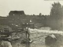
| Date: | |
|---|---|
| Description: | Looking east at Terminal Moraine topography. View is down a dirt road with a house in the near background. |
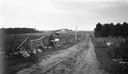
| Date: | |
|---|---|
| Description: | German farm couple returning from the fields, crossing railroad tracks. |
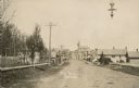
| Date: | 1895 |
|---|---|
| Description: | Elevated view down Main Street, which crosses railroad tracks in the foreground. There are two signs in the foreground which say: "Look Out for the Cars" a... |

| Date: | 08 14 1932 |
|---|---|
| Description: | The watershed sign unveiled. The marker is 39 miles south of Ashland adjacent to Highway 13, 2 miles north of Gordon Lake. |

| Date: | 08 14 1932 |
|---|---|
| Description: | Watershed sign unveiled with ceremony participants. The marker is 39 miles south of Ashland adjacent to Highway 13, 2 miles north of Gordon Lake. |
| Date: | 1910 |
|---|---|
| Description: | View of Main Street when it was a dirt road. A church is in the background, and telephone poles are along the left side of the road. A streetlight is hangi... |

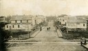
| Date: | 1902 |
|---|---|
| Description: | Slightly elevated view looking down Main Street, with people walking on the wooden sidewalks, horse and carriages driving down the street and storefronts w... |

| Date: | 1931 |
|---|---|
| Description: | View looking east on Grant Street in Glidden Wisconsin. |
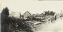
| Date: | 1916 |
|---|---|
| Description: | The Gang's first camp of the trip, set up near Glidden. There are two tents set up in a field, and a house is in the far background. |
If you didn't find the material you searched for, our Library Reference Staff can help.
Call our reference desk at 608-264-6535 or email us at: