 Filter: Categories of Wisconsin Historical Images
Filter: Community of Green Bay
Filter: Subject of intellectual life
Filter: Type of Map or Atlas
Filter: Categories of Wisconsin Historical Images
Filter: Community of Green Bay
Filter: Subject of intellectual life
Filter: Type of Map or Atlas

| Date: | 1867 |
|---|---|
| Description: | Bird's-eye map of Green Bay and Fort Howard, Brown Co., depicts street names and street layouts, houses, trees, and the East River. A reference key at the ... |

| Date: | 1893 |
|---|---|
| Description: | Bird's-eye map of Green Bay and Fort Howard, looking south. Ninety-four locations identified below image; extends to Grignon Street at top left corner, Wi... |
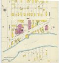
| Date: | 1907 |
|---|---|
| Description: | A Sanborn map of Green Bay, prominently featuring the East River. |
If you didn't find the material you searched for, our Library Reference Staff can help.
Call our reference desk at 608-264-6535 or email us at: