Filter: Categories of Wisconsin Historical Images
Filter: Community of Green Bay
Filter: Subject of intellectual life
Filter: Subject of transportation
Filter: Categories of Wisconsin Historical Images
Filter: Community of Green Bay
Filter: Subject of intellectual life
Filter: Subject of transportation

| Date: | 1867 |
|---|---|
| Description: | Bird's-eye map of Green Bay and Fort Howard, Brown Co., depicts street names and street layouts, houses, trees, and the East River. A reference key at the ... |
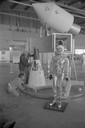
| Date: | 1965 |
|---|---|
| Description: | A traveling display about the NASA manned space program on exhibit at Austin Straubel Airport. Included in the exhibit is a model of a space capsule and a ... |
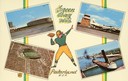
| Date: | 1957 |
|---|---|
| Description: | Composite image of "Packerland U.S.A." including prominent attractions: Lambeau Field, home of the Green Bay Packers, NFL Football team; the Brown County A... |
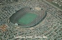
| Date: | 1965 |
|---|---|
| Description: | Aerial view of Lambeau Field, home the Green Bay Packers football team, with a full parking lot. The capacity of the stadium at the time of this photograp... |
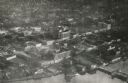
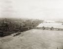
| Date: | 1920 |
|---|---|
| Description: | Aerial view of the commercial district on the east side of the Fox River. Left to right: Hurlbut Coal Company; suggested location for small terminal; Main... |
| Date: | 1924 |
|---|---|
| Description: | Aerial view of Green Bay's commercial district, bridges, and water. |
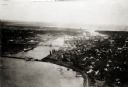
| Date: | 1920 |
|---|---|
| Description: | Aerial view with fishing piers, coal factories, a bridge, and railroad tracks. |
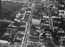
| Date: | 1890 |
|---|---|
| Description: | Aerial view of downtown Green Bay, with the old Court House. |
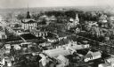
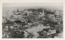
| Date: | 1890 |
|---|---|
| Description: | Aerial view of downtown Green Bay with old Court House and the surrounding buildings. |
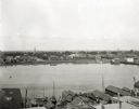
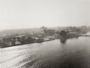
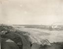
| Date: | 1903 |
|---|---|
| Description: | Aerial view of the Green Bay harbor area. |
| Date: | 1925 |
|---|---|
| Description: | Aerial view of Green Bay, including the Jorgensen-Blesch Company building and two bridges. |
| Date: | 1920 |
|---|---|
| Description: | Aerial view of with bridges, river, and shoreline. |

| Date: | 1950 |
|---|---|
| Description: | Aerial view of downtown and river. |

| Date: | |
|---|---|
| Description: | Aerial view of a train crossing the East River in a rural community south of Green Bay. Some buildings are visible to the right and the background of the i... |

| Date: | |
|---|---|
| Description: | Aerial view includes farm and orchards, surrounded by neighborhoods. A water tower is on the upper left half. |
| Date: | |
|---|---|
| Description: | Letterhead of the Farmers Exchange Bank of Green Bay, Wisconsin, with a three-quarter view of the bank building and people walking on the sidewalk. There a... |

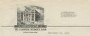
| Date: | |
|---|---|
| Description: | Memohead of the Henry Rahr Sons' Company of Green Bay, Wisconsin, brewers and maltsters, with an elevated view of the main office at 1317-1323 Main St. on ... |

| Date: | |
|---|---|
| Description: | Memohead of the Green Bay Transportation Company, with a center image of a steamer traveling on the water and a life preserver on one side printed with the... |
If you didn't find the material you searched for, our Library Reference Staff can help.
Call our reference desk at 608-264-6535 or email us at: