 Filter: Categories of Wisconsin Historical Images
Filter: Community of Green Bay
Filter: Subject of land
Filter: Subject of architecture
Filter: Categories of Wisconsin Historical Images
Filter: Community of Green Bay
Filter: Subject of land
Filter: Subject of architecture

| Date: | 1867 |
|---|---|
| Description: | Bird's-eye map of Green Bay and Fort Howard, Brown Co., depicts street names and street layouts, houses, trees, and the East River. A reference key at the ... |

| Date: | 1953 |
|---|---|
| Description: | Captain John Cotton residence. Also known as "Beaupre," this Greek Revival style house was built in 1842 for Cotton, a retired U.S. Army officer. |
| Date: | 1898 |
|---|---|
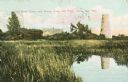
| Description: | Caption reads: "Old Stone Tower and House, Long Tail Point, Green Bay, Wis." Water and a marshy area are in the foreground. |

| Date: | 1905 |
|---|---|
| Description: | Long Tail Lighthouse and surrounding buildings. |
| Date: | 1910 |
|---|---|
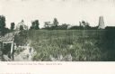
| Description: | Caption reads: "Old Light House at Long Tail Point, Green Bay, Wis." Built in 1859. A marshy area is in the foreground, and a long pier leads to the new li... |

| Date: | 1910 |
|---|---|
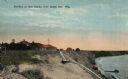
| Description: | View from road toward Mineral Springs. There is a board sidewalk in the foreground. Caption reads: "Mineral Sprints, Green Bay, Wis." |

| Date: | 08 18 1963 |
|---|---|
| Description: | Two children stand on an outdoor stairway of wood-shingle house. Caption on back of print reads, "Back steps in 'Goosetown.' a section around Broadway and ... |

| Date: | 1900 |
|---|---|
| Description: | This photostat of a manuscript map originally drawn in 1829 shows landownership, buildings, including Fort Howard and U.S. sawmill, swamps, public barns an... |

| Date: | 1862 |
|---|---|
| Description: | This map shows landownership on a military reserve, private claims, buildings (including Fort Howard and U.S. sawmill), swamps, public barns and fields, an... |

| Date: | 1917 |
|---|---|
| Description: | Photographic postcard of a view under the wing of a Lawson Military Tractor 2 (MT2) in flight. Below is a field and beyond are buildings and a body of wate... |
| Date: | |
|---|---|
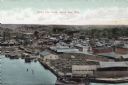
| Description: | Bird's-eye view of Green Bay from the waterfront, with commercial buildings and factories. Caption reads: "Bird's Eye View, Green Bay, Wis." |
| Date: | 1926 |
|---|---|
| Description: | Colorized postcard of a beachside pavilion and the long, wooden staircase leading down to the waterfront. Caption reads: "Pavilion at Red Banks, near Green... |

| Date: | |
|---|---|
| Description: | Hand-colored postcard elevated view of buildings along the Fox River. Boats moored in the foreground. A train is passing by across the river. Old Fort Howa... |

| Date: | 1818 |
|---|---|
| Description: | Overhead view of the layout of the fort, with the Fox River at the top, and a "Cranberry Marsh of 1/2 mile in extent" below right. At the bottom is a rende... |
If you didn't find the material you searched for, our Library Reference Staff can help.
Call our reference desk at 608-264-6535 or email us at: