 Filter: Categories of Wisconsin Historical Images
Filter: Community of Green Bay
Filter: Subject of land
Filter: Subject of church buildings
Filter: Categories of Wisconsin Historical Images
Filter: Community of Green Bay
Filter: Subject of land
Filter: Subject of church buildings

| Date: | 1867 |
|---|---|
| Description: | Bird's-eye map of Green Bay and Fort Howard, Brown Co., depicts street names and street layouts, houses, trees, and the East River. A reference key at the ... |

| Date: | 1900 |
|---|---|
| Description: | This set of maps contains four sheets: "Landownership in the Vicinity of Military Reserve and Fort Howard," "Houses Along the River Road to Green Bay," "Ow... |
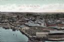
| Date: | |
|---|---|
| Description: | Bird's-eye view of Green Bay from the waterfront, with commercial buildings and factories. Caption reads: "Bird's Eye View, Green Bay, Wis." |
If you didn't find the material you searched for, our Library Reference Staff can help.
Call our reference desk at 608-264-6535 or email us at: