 Filter: Categories of Wisconsin Historical Images
Filter: Community of Green Bay
Filter: Subject of land
Filter: Categories of Wisconsin Historical Images
Filter: Community of Green Bay
Filter: Subject of land

| Date: | 1960 |
|---|---|
| Description: | This map is a facsimile of a 1829 map and shows private land claims, landowners within military reserve boundaries, sawmill, Fort Howard, public barns, bri... |

| Date: | 04 11 1940 |
|---|---|
| Description: | This blue line print map shows survey monument markers by type and industrial buildings and covers part of the lower Fox River and East River. The map incl... |

| Date: | 1917 |
|---|---|
| Description: | View over the wing of a Lawson Military Tractor 2 (MT2) in flight. Below are houses and what may be a river or lake. Location is unknown, but is probably n... |

| Date: | 1917 |
|---|---|
| Description: | Photographic postcard of a view under the wing of a Lawson Military Tractor 2 (MT2) in flight. Below is a field and beyond are buildings and a body of wate... |

| Date: | 1917 |
|---|---|
| Description: | Photographic postcard showing of a view behind the wing of a Lawson Military Tractor 2 (MT2). Below are fields and in the distance are houses. The photogra... |

| Date: | 1900 |
|---|---|
| Description: | This set of maps contains four sheets: "Landownership in the Vicinity of Military Reserve and Fort Howard," "Houses Along the River Road to Green Bay," "Ow... |
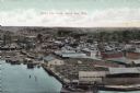
| Date: | |
|---|---|
| Description: | Bird's-eye view of Green Bay from the waterfront, with commercial buildings and factories. Caption reads: "Bird's Eye View, Green Bay, Wis." |
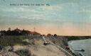
| Date: | 1926 |
|---|---|
| Description: | Colorized postcard of a beachside pavilion and the long, wooden staircase leading down to the waterfront. Caption reads: "Pavilion at Red Banks, near Green... |

| Date: | |
|---|---|
| Description: | Hand-colored postcard elevated view of buildings along the Fox River. Boats moored in the foreground. A train is passing by across the river. Old Fort Howa... |

| Date: | 1947 |
|---|---|
| Description: | Elevated view of the bridge and main building on the opposite shoreline at Pamperin Park. Caption reads: "Pamperin Park, Green Bay, Wis." |

| Date: | 1818 |
|---|---|
| Description: | Overhead view of the layout of the fort, with the Fox River at the top, and a "Cranberry Marsh of 1/2 mile in extent" below right. At the bottom is a rende... |
If you didn't find the material you searched for, our Library Reference Staff can help.
Call our reference desk at 608-264-6535 or email us at: