 Filter: Categories of Wisconsin Historical Images
Filter: Community of Green Bay
Filter: Subject of locks (hydraulic engineering)
Filter: Categories of Wisconsin Historical Images
Filter: Community of Green Bay
Filter: Subject of locks (hydraulic engineering)
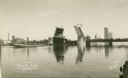
| Date: | 1927 |
|---|---|
| Description: | Main Street Bridge raised to let boats pass through the locks on the Fox River. |

| Date: | 1868 |
|---|---|
| Description: | Map showing the northern water routes between Mississippi River and Atlantic Ocean Relief shown by hachures. Includes Profile of the Erie Canal, table of ... |
If you didn't find the material you searched for, our Library Reference Staff can help.
Call our reference desk at 608-264-6535 or email us at: